Approximate Location Map
Large Map »
Latitude: 53.325 / 53°19'30"N
Longitude: -0.1145 / 0°6'52"W
OS Eastings: 525681
OS Northings: 382555
OS Grid: TF256825
Mapcode National: GBR WYNZ.0S
Mapcode Global: WHHJY.6PRB
Plus Code: 9C5X8VGP+26
Entry Name: Chain Home Transmitter Tower, former RAF Stenigot
Listing Date: 22 January 1997
Last Amended: 8 September 2020
Grade: II*
Source: Historic England
Source ID: 1259301
English Heritage Legacy ID: 463018
Also known as: Chain Home Transmitter Tower at TF 2568 8255, former Raf Stenigot
ID on this website: 101259301
Location: East Lindsey, Lincolnshire, LN11
County: Lincolnshire
District: East Lindsey
Civil Parish: Donington on Bain
Traditional County: Lincolnshire
Lieutenancy Area (Ceremonial County): Lincolnshire
Church of England Parish: Asterby Group
Church of England Diocese: Lincoln
Tagged with: Transmitter mast
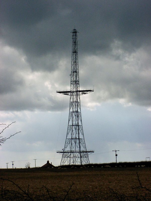
A Chain Home radar transmitter tower of 1939, built by Blaw Knox ltd, the design is one of three approved variants to the specifications produced by Air Ministry engineer Norman Garnish. The variant here is designated as a Group 1 type.
A Chain Home radar transmitter tower of 1939, built by Blaw Knox ltd, the design is the first of three approved variants (designated Group 1) to the specifications produced by Air Ministry engineer Norman Garnish.
MATERIALS: the tower is built of bolted galvanised steel girders, with steel ladders and platforms. The platforms have timber floor boarding. The tower stands on four concrete pads.
PLAN: The tower is rectangular on plan, and stands to the south of the transmitter block.
EXTERIOR: a self-supporting 360 feet (109.72m) high steel lattice tower with internal ladders and landing stages. The tower has a foot at each corner, each sitting on a concrete pad. Two pairs of cantilevered platforms extend from the sides at 50 feet (15.2m) and 200 feet (60.95m). A higher pair of platforms originally located at 350 feet (106.67m) up the tower has been removed.
Chain Home was the name given to the network of Royal Air Force (RAF) early warning Radio Direction Finding (RDF) stations, later called radar, developed in the late 1930s. They were utilised throughout the Second World War, most famously in the Battle of Britain of 10 July 1940 – 31 October 1940. This was the world’s first use of radar technology in an operational early warning air defence system.
After the First World War the public mood in Britain was very much one in favour of disarmament and pacifism; but by the early 1930s there were also growing fears over German rearmament. The greatest perceived threat was aerial bombardment of civilians in cities. The prevailing assumption at the time was that ‘the bomber will always get through’ – a phrase used by Stanley Baldwin in a 1932 speech to the House of Commons. The new German bombers were much faster than those used in the First World War, making existing air defences obsolete. Despite the introduction of new single wing Hurricane and Spitfire fighters in the late 1930s, there was concern from military and political perspectives that Britain was underprepared for aerial attack.
Hugh Dowding was the commanding officer of RAF Fighter Command from 1936 until November 1940. His strategy was, contrary to the common belief in the invincibility of bombers, to place faith in the ability of fighter aircraft to intercept bombing raids. Dowding oversaw the development of a complex air defence system that would allow the most efficient use of limited British air power in case of enemy aerial attack. The Dowding system combined ground observations made by the volunteer Observer Corps (Royal Observer Corps from 1941) with new RDF / radar technology, telephone communication and systematic manual plotting on maps. During the Battle of Britain, this information was collated and acted upon in the Filter Room at Fighter Command, RAF Bentley Priory, in Stanmore, north London (Central entrance block listed at Grade II* - NHLE 1358638). In practice the system enabled locations of German bombers to be relayed to fighter squadrons in time for them to be deployed and meet the invaders before they had reached their targets. The effectiveness of the Dowding system is widely credited for preventing German victory in the Battle of Britain.
The radar element of the Dowding system was the Chain Home network of stations along the eastern and southern coasts of England and Scotland. The idea of radar stems from C19 discoveries that radio waves are reflected back in an echo from solid objects. The essentials of a radar system are that radio or microwaves are transmitted and received, and data from the received waves are processed to provide information about the location and speed of travel of any object the waves have reflected back from. British government efforts to research new means of air defence resulted in trials of a radio wave system for detecting aircraft devised by Scottish radio physicist Robert Watson-Watt and his assistant Arnold Wilkins. These trials carried out in 1935 were successful.
By the summer of 1936 Bawdsey Manor in Suffolk had been purchased by the Air Ministry and was in use as a centre for new aerial defence research, building on early successes achieved at nearby Orford Ness. It was at Bawdsey that the first working Chain Home station was completed, leading in August 1937 to the commissioning of a full chain of stations to be sited at roughly 40 mile intervals along the south and east coasts of England and Scotland. The station at Bawdsey became the prototype for the layout of equipment and buildings that was used throughout the chain. The transmitter and receiver blocks at Bawdsey survive, the transmitter is listed at Grade II* (NHLE 1245307), and the receiver at Grade II (NHLE 1245202).
Given the urgent need for the system to be operational as soon as possible, the Chain Home network was technologically quite crude, even by the standards of its day. Largely it used existing readily available components rather than those purpose designed for the task. Despite its rudimentary technology, the system was effective and could detect aircraft at an altitude of 15000 feet over 100 miles away. The requisites for a functioning station as developed at Bawdesy were a transmitter block broadcasting through aerials arranged over four 360 foot (109.72m) high steel transmitter towers, and a receiving block linked to four 240 feet (73.15m) high timber receiving towers. The stations transmitted using High Frequency (HF) long wave radio waves. There were four towers as it was originally planned for the stations to switch between four different frequencies to avoid enemy jamming of the signal. The transmitter towers were arranged in a straight line with the transmitter block centrally located off the line of towers. The receiver towers were in a quadrangular formation around the central receiver block. The transmitter aerials on the towers were accessed via three cantilevered pairs of platforms at heights of 15.2 m (50 feet), 60.95m (200 feet) and 106.67m (350 feet) up the towers. Initially, the aerials were held in cradles extended on an arm from the platforms, later they were suspended in arrays between towers in a ‘curtain’, fed by transmission lines leading from the transmitter building.
The requirements for a Chain Home Station site were that it should be on ground at least 50 feet (15.2m) above sea level, and close to the coast. The aerials transmitted radio waves in all directions, so reflections from below and behind (inland) would make the vital signals from the coast difficult to distinguish. The height of the aerials from the ground, and the ground being level or smoothly sloping allowed the downward reflection to be mitigated. A reflector curtain was positioned inland to the west, redirecting the radio waves back out to sea and avoiding confusing readings received from objects and higher ground inland. The result was that radio waves were pulsed out in a lobe with a fixed arc of around 100 degrees, centred on a ‘line of shoot’ bearing. The towers were immobile, so this line could not be adjusted. To ensure full coverage of the coast, each station’s range slightly overlapped that of its neighbours in the chain. Stenigot was complemented by stations at RAF Staxton Wold to the north in North Yorkshire, and RAF West Beckham to the south in Norfolk.
By the time of the Battle of Britain in 1940 there were 21 stations including Bawdsey, stretching from Ventnor on the Isle of Wight to Netherbutton on Mainland in the Orkneys. The site at Stenigot was selected in September 1937 to be one of the stations in the initial full chain of stations to protect the whole east of Britain. Stenigot was chosen because it occupies the highest ground in eastern England between Kent and Yorkshire, at 151m above sea level. Work was started in 1938 and the station was functional in February 1939. Stenigot is unusual for a Chain Home Station in that the four transmitter towers were aligned at an angle to each other, not square on. The transmitter towers were 210 feet (64m) apart, centre to centre. It is only the southernmost of these towers that survives. The transmitter block is extant and is listed Grade II (NHLE 1259212). The receiving equipment was set out more conventionally in line with the Bawdsey model with the four towers in a diamond pattern around the receiver block. None of these towers survive. Power was supplied direct from the National Grid, but there was a stand-by sethouse with generator for power in the centre of the station. Other ancillary buildings were located around the transmitter towers to the south of the site. The receiver complex was to the north of the site. The site was defended by pillboxes, and buildings were of blast-proof design with turf revetments. The station employed around 120 people, with staff accommodation in a separate ‘B site’ area to the north and east of the technical ‘A’ site. Following attacks on Chain Home stations during the Battle of Britain, efforts were made to increase the operational security of the sites. This was achieved by installing fully buried complete duplicate transmitter and receiver blocks, safe in reserve in case of enemy damage to the above ground originals. This idea was trialled at Stenigot with work beginning in October 1940, other stations adopted the practice later.
As the Second World War progressed, there was rapid development of more sophisticated radar technology, resulting in the original Chain Home network becoming a supplementary system rather than the main line of defence. In 1941 Stenigot was one of the stations for the new Gee radar navigation system which helped guide allied bombers. From November 1943 many of the original Chain Home stations were dismantled or operated on reduced watches, with only a few continuing in full operation. Stenigot was one of six Chain Home stations left fully operational after the Second World War and retained as part of an early warning system, upgraded to a ‘Rotor’ radar site in the early 1950s. From 1960 RAF Stenigot was used as a relay station in the Nato ‘Ace High’ communications system, when four large parabolic dishes were erected at the northern end of the site. This equipment was decommissioned in the early 1990s, and only one dish remains on site, now removed from its supporting frame.
The current site is 5.56 hectares (13.729 acres). Most of the buildings on the site were demolished in the late 1990s, including the listed Chain Home receiver block (500m to the north-west of the surviving tower at TF 25420 82990), now de-listed. Gates and a water tower survive at the accommodation ‘B’ site 200m to the north-east of the tower. The most recent uses of the transmitter tower are as a cellular telephone relay and for height aptitude training.
Four transmitter towers from the original Chain Home network are listed. The most complete surviving tower was originally at RAF Canewdon but in 1956 it was moved to Great Baddow; it is listed at Grade II (NHLE 1456445). The transmitter tower at RAF Stenigot is the most complete transmitter tower still in its original location, but it has lost its top pair of platforms. The tower at Swingate (NHLE 1405535) has lost all its platforms, but is listed at Grade II* for being the earliest surviving tower and having been involved in enemy action due to close proximity to the German bases in France. A tower survives at Dunkirk, Kent, it has been truncated and is listed at Grade II (NHLE 1031910).
The Chain Home Transmitter Tower at RAF Stenigot is listed at Grade II* for the following principal reasons:
Architectural Interest:
* the tower at Stenigot is the best preserved and most complete Chain Home transmitter tower surviving in its original location in the British Isles; it stands to its full height and retains four of its six working platforms;
* as a strikingly tall self-supporting steel structure standing to a height of 360 feet (109.72m), the tower is a rare and visible survival of pre-Second World War communication equipment.
Historic Interest:
* as a physical manifestation of pre-war tensions and fears of aerial attack which anticipated the need for a national air defence system;
* the Chain Home stations were decisive in providing early warning of German aerial attacks, playing a crucial role in the air defence of the country during the Battle of Britain and changing the course of the Second World War;
* the early date of the tower has considerable significance; both in the story of radar where the Chain Home system was the world first for the applied use of this technology and in the wider development of electronics in the C20;
* the tower has group value with the transmitter block (Grade II listed National Heritage List for England 1259212) which together advance the appreciation and understanding of the operation of the radar station. There is also group value with the unlisted structures of the base which continue the story of the development of radar and satellite communications from the Second World War through to the Cold War.
External links are from the relevant listing authority and, where applicable, Wikidata. Wikidata IDs may be related buildings as well as this specific building. If you want to add or update a link, you will need to do so by editing the Wikidata entry.


Other nearby listed buildings
