Approximate Location Map
Large Map »
Latitude: 53.5127 / 53°30'45"N
Longitude: -2.2894 / 2°17'21"W
OS Eastings: 380906
OS Northings: 401823
OS Grid: SD809018
Mapcode National: GBR D73.0S
Mapcode Global: WH983.TY0Y
Plus Code: 9C5VGP76+36
Entry Name: Boundary Stone at SD8090601825 at the Junction with Singleton Brook
Listing Date: 20 October 1998
Last Amended: 14 July 2010
Grade: II
Source: Historic England
Source ID: 1386143
English Heritage Legacy ID: 471567
ID on this website: 101386143
Location: Rainsough, Salford, Greater Manchester, M7
County: Salford
Electoral Ward/Division: Kersal
Parish: Non Civil Parish
Built-Up Area: Salford
Traditional County: Lancashire
Lieutenancy Area (Ceremonial County): Greater Manchester
Church of England Parish: Kersal Moor St Paul
Church of England Diocese: Manchester
Tagged with: Boundary marker
The asset was previously listed twice also under List entry 1393874. This entry was removed from the List on 30 October 2017.
949-1/2/122
20-OCT-98
LITTLETON ROAD
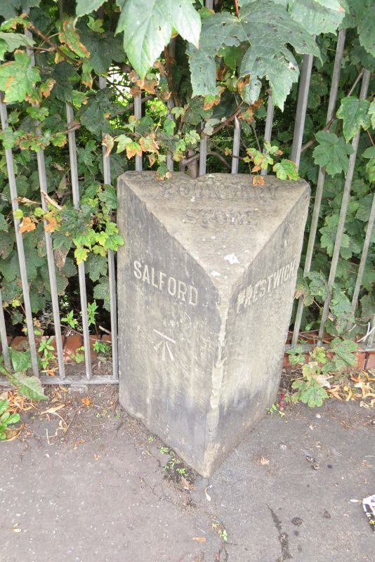
BOUNDARY STONE AT SD8090601825 AT THE JUNCTION WITH SINGLETON BROOK
(Formerly listed as: BOUNDARY STONE AT SD8090601825 AT THE JUNCTION WITH SINGLETON BROOK (THAT PART IN SALFORD DISTRICT) and BOUNDARY STONE AT SD8090601825 AT THE JUNCTION WITH SINGLETON BROOK (THAT PART IN BURY DISTRICT))
(Formerly listed as LITTLETON ROAD, BOUNDARY STONE AT SD 809 018 (JUNCTION WITH SINGLETON BROOK)).
II
Boundary stone. 1853. Ashlar. Triangular plan. Inscribed "SALFORD/ PRESTWICH" and on chamfered top "BOUNDARY STONE". Denotes the boundary (along the line of Singleton Brook) between Prestwich (in Bury) and Salford. Probably erected in 1853, the year when the 3 townships of Broughton, Pendleton and Salford were brought together to form the new County Borough of Salford. Forms a group with the boundary stones in Bury Old Road (qv) and Singleton Road (qv).
REASONS FOR DESIGNATION
The Boundary Stone at the Junction with Singleton Brook, dated 1853, is designated at Grade II for the following principal reasons:
* Date: It is a good example of a mid C19 boundary stone, which still survives in its original form.
* Historical: It marks a change in local government boundaries when the townships of Broughton, Pendleton and Salford were brought together and formed the new County Borough of Salford.
External links are from the relevant listing authority and, where applicable, Wikidata. Wikidata IDs may be related buildings as well as this specific building. If you want to add or update a link, you will need to do so by editing the Wikidata entry.


Other nearby listed buildings
