Approximate Location Map
Large Map »
Latitude: 50.9092 / 50°54'32"N
Longitude: -1.4416 / 1°26'29"W
OS Eastings: 439354
OS Northings: 112335
OS Grid: SU393123
Mapcode National: GBR RKD.T0
Mapcode Global: FRA 76WP.S6S
Plus Code: 9C2WWH55+M9
Entry Name: King George V Dry Dock
Listing Date: 5 June 2006
Grade: II
Source: Historic England
Source ID: 1391678
English Heritage Legacy ID: 495151
Also known as: King George V Graving Dock
ID on this website: 101391678
Location: Regents Park, Southampton, Hampshire, SO15
County: City of Southampton
Electoral Ward/Division: Millbrook
Parish: Non Civil Parish
Built-Up Area: Southampton
Traditional County: Hampshire
Lieutenancy Area (Ceremonial County): Hampshire
Church of England Parish: Millbrook Holy Trinity
Church of England Diocese: Winchester
Tagged with: Architectural structure
983/0/10063 WESTERN DOCKS
05-JUN-06 King George V Dry Dock
II
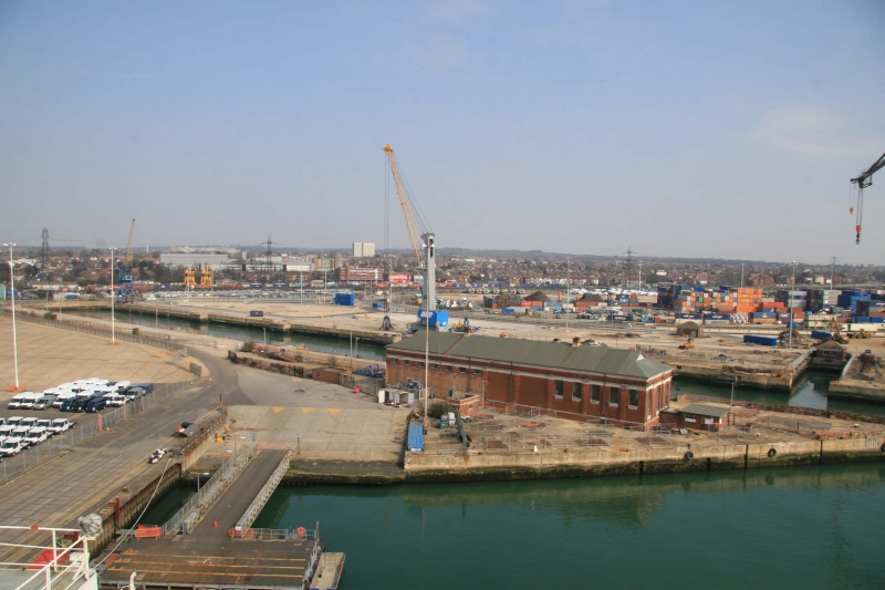
King George V Graving Dock, also known as No. 7 Dry Dock, is a dry dock located in Southampton's Western Docks. It was designed by FE Wentworth-Shields and constructed by John Mowlem & Company, with Edmund Nuttall Sons & Company. It was formally opened by HM King George V and Queen Mary on 26th July 1933, but work was not completed until 1934.
MATERIALS: The dock is constructed of reinforced concrete and steel, which was introduced as a building material at the end of C19. The only granite used in the construction was for the sills and caisson stops, the flights of steps leading to the floor, and the coping of the walls at the entrance. All other parts of the dock, including the copings of the side walls and the altar steps near the base, are of concrete.
PLAN: The shape of the cross section of docks mirrored the developments in ship design. C17 to late C19 docks had curving or semi-circular cross sections due to the shape of the hulls of ships built at that time. The sloping walls of the docks had steps, called altars, which provided footings for the timber props which supported the ship's hull. In the early C20 dock profiles became more trapezoidal, and, by the mid C20, rectangular with near vertical walls. The King George V Graving Dock mirrors these developments, and has steep sides with a restricted number of stepped altars, which are confined to the base of the walls. It was found that high-level altars were not needed, and that large ships could dock on three lines of blocks without the need for shoring.
DESCRIPTION: The dock is 1,200 feet long and 135 feet wide. Mooring bollards are spaced at intervals along the sides of the dock, and others set into the dock wall. In addition, there are service access points and inspection slipways on either side of the dock. At the east side of the dock entrance is the chamber for the caisson door, although the caisson has been removed.
The side and end walls of the dock were constructed with a batter of 1 in 4 to resist the lateral earth pressure and to economise on concrete. Despite this a large quantity of concrete was used. The floor of the dock is 25ft thick at the centre line, tapering to 17.5ft thick at the sides where it adjoins the walls. The most unusual aspect of the dock's design is the provision of vertical buttresses, or piers, which project from the side of the dock at 200ft intervals. These piers were needed to prevent the bilge keels of vessels striking the base of the battered walls, and the faces of the piers were fendered for about 10ft below the coping with English elm timbers. This gave the structure a distinctive, Modernist, architectural character.
HISTORY: The Dock was designed for the repair and maintenance of the largest ocean liners operating at this time, and two years after its opening, the Queen Mary used it before embarking on her maiden voyage. It was intended to uphold Southampton's position as Britain's premier passenger port. Its construction involved major engineering work including the construction of deep wells and the use of pumps to lower the water table. This was thought to be the first application of the deep well method since Robert Stephenson constructed the Kilsby tunnel a century earlier. It remained the longest dry dock in the world for almost 30 years, and by 1939 was attracting half a million sightseers each year who came to see the world's largest liners. During WWII the Western Docks, of which King George V Graving Dock is a part, was one of the principal embarkation points for Operation 'Overlord', and the famous Mulberry Harbour, used in the D-Day landings in June 1944, was constructed there. By the 1960's the great era of the transatlantic passenger liner was ending due to the rise of the jet airliner. Since the 1950's, the other dry docks at Southampton have all been infilled, apart from No.6 Trafalgar Dry Dock, the design of which included work by Wentworth-Shields. These two docks represent the great achievements of Southampton Docks' development during the first half of the C20.
SUMMARY OF IMPORTANCE: King George V Graving Dock has special historic interest both locally and nationally as a rare survival from the heyday of the transatlantic liner era. It has special architectural interest as a good example of the evolution of dock design as it stood in the mid C20, innovative in its construction. The dock has associations with great ships and events important in British history, and was the most significant dry dock in one of Britain's leading ports.
SOURCES: Clarke, Jonathan, King George V Graving Dock, Western Docks, Southampton (English Heritage Architectural Investigation London & South, January 2006).
External links are from the relevant listing authority and, where applicable, Wikidata. Wikidata IDs may be related buildings as well as this specific building. If you want to add or update a link, you will need to do so by editing the Wikidata entry.


Other nearby listed buildings
