Approximate Location Map
Large Map »
Latitude: 53.3833 / 53°22'59"N
Longitude: -2.6225 / 2°37'20"W
OS Eastings: 358691
OS Northings: 387567
OS Grid: SJ586875
Mapcode National: GBR BY49.1W
Mapcode Global: WH98Q.P7D3
Plus Code: 9C5V99MH+82
Entry Name: The Black Horse Public House
Listing Date: 4 April 1975
Grade: II
Source: Historic England
Source ID: 1139396
English Heritage Legacy ID: 58813
ID on this website: 101139396
Location: Sankey Bridges, Warrington, Cheshire, WA5
County: Warrington
Electoral Ward/Division: Great Sankey South
Parish: Non Civil Parish
Built-Up Area: Warrington
Traditional County: Lancashire
Lieutenancy Area (Ceremonial County): Cheshire
Church of England Parish: Warrington St Barnabas
Church of England Diocese: Liverpool
Tagged with: Pub
LIVERPOOL ROAD
1.
5150
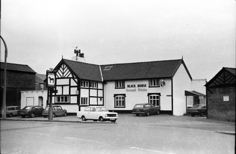
The Black Horse
Public House
SJ 58 NW 5/89
II
2.
Dated RB1632. Restored and modernised, but retains some character. L plan.
Timbered gable to wing, with low horizontal windows. Main block has 2 windows
each floor (2 storeys). Slate roof. Roughcast walls.
Listing NGR: SJ5869187567
External links are from the relevant listing authority and, where applicable, Wikidata. Wikidata IDs may be related buildings as well as this specific building. If you want to add or update a link, you will need to do so by editing the Wikidata entry.


Other nearby listed buildings
