Approximate Location Map
Large Map »
Latitude: 54.2329 / 54°13'58"N
Longitude: -2.7704 / 2°46'13"W
OS Eastings: 349876
OS Northings: 482186
OS Grid: SD498821
Mapcode National: GBR 9M3H.0C
Mapcode Global: WH838.DVZV
Plus Code: 9C6V66MH+5R
Entry Name: St Anthony's Tower Approximately 150 Metres East of A6 North of Milnthorpe
Listing Date: 16 November 1984
Grade: II
Source: Historic England
Source ID: 1350009
English Heritage Legacy ID: 75553
ID on this website: 101350009
Location: Milnthorpe, Westmorland and Furness, Cumbria, LA7
County: Cumbria
District: South Lakeland
Civil Parish: Milnthorpe
Built-Up Area: Milnthorpe
Traditional County: Westmorland
Lieutenancy Area (Ceremonial County): Cumbria
Church of England Parish: Milnthorpe St Thomas
Church of England Diocese: Carlisle
Tagged with: Tower
SD 48 SE MILNTHORPE A6 (off East side)
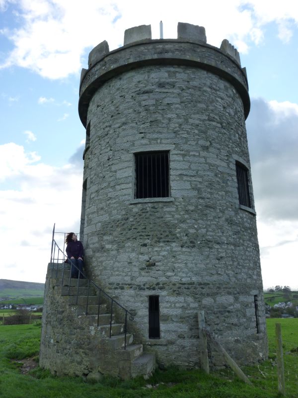
3/1 St Anthony's Tower
approx.150 m East
of A6 North of
Milnthorpe
II
Folly in shape of Tower. Probably early C19 (recorded as in existence by
1832). Stone rubble with dressed stone corniced parapet. Circular plan. 2
storeys. 5 window openings, not glazed with roughly cut lintels and cills and
and doors approached by flight of external steps at first floor. Ground floor
has window opening to south and slit openings to remaining sides. Visible as
landscape feature from some considerable distance all round, notably from Dallam
Towers whose owner in 1832 prevented any further extension of the development
along Church Street in Milnthorpe so that his view of the folly from his house
was not obscured. Further information: CURWEN, J F History of Heversham with
Milnthorpe, pub. Titus Wilson 1930, p11.
Listing NGR: SD4987682186
External links are from the relevant listing authority and, where applicable, Wikidata. Wikidata IDs may be related buildings as well as this specific building. If you want to add or update a link, you will need to do so by editing the Wikidata entry.


Other nearby listed buildings
