Approximate Location Map
Large Map »
Latitude: 54.2066 / 54°12'23"N
Longitude: -3.1411 / 3°8'27"W
OS Eastings: 325669
OS Northings: 479589
OS Grid: SD256795
Mapcode National: GBR 6MHS.RS
Mapcode Global: WH724.QJFG
Plus Code: 9C6R6V45+MH
Entry Name: Devils Bridge
Listing Date: 25 March 1970
Grade: II
Source: Historic England
Source ID: 1311386
English Heritage Legacy ID: 75879
ID on this website: 101311386
Location: Westmorland and Furness, Cumbria, LA12
County: Cumbria
District: South Lakeland
Civil Parish: Pennington
Traditional County: Lancashire
Lieutenancy Area (Ceremonial County): Cumbria
Church of England Parish: Pennington St Michael and the Holy Angels
Church of England Diocese: Carlisle
SD 27 NE,
16/105
PENNINGTON,
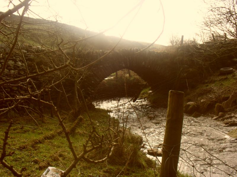
Devils Bridge
25.03.70
II
Packhorse bridge to north-west side of road. C17 or C18. Stone rubble.
Segmental arch with thin voussoirs of varying lengths. Low parapet of upright
stones. 2m wide.
Listing NGR: SD2566979589
External links are from the relevant listing authority and, where applicable, Wikidata. Wikidata IDs may be related buildings as well as this specific building. If you want to add or update a link, you will need to do so by editing the Wikidata entry.


