Approximate Location Map
Large Map »
Latitude: 54.3956 / 54°23'44"N
Longitude: -3.2499 / 3°14'59"W
OS Eastings: 318945
OS Northings: 500735
OS Grid: NY189007
Mapcode National: GBR 5KRM.62
Mapcode Global: WH714.1SP3
Plus Code: 9C6R9QW2+62
Entry Name: Doctor Bridge
Listing Date: 21 January 1985
Grade: II
Source: Historic England
Source ID: 1336032
English Heritage Legacy ID: 76198
ID on this website: 101336032
Location: Cumberland, Cumbria, CA19
County: Cumbria
District: Copeland
Civil Parish: Eskdale
Traditional County: Cumberland
Lieutenancy Area (Ceremonial County): Cumbria
Church of England Parish: Eskdale St Catherine
Church of England Diocese: Carlisle
Tagged with: Bridge Packhorse bridge
NY 10 SE ESKDALE
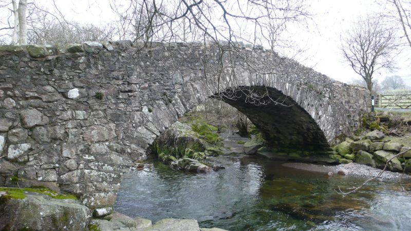
15/6 Doctor Bridge
II
Packhorse bridge, now road bridge. Probably C17, widened in 1734 for Edward
Tyson, surgeon, to take his trap. Snecked rubble. Single segmental arch
spanning c30 ft. Roadway c9 ft wide (straight joint to arch soffit shows
original bridge - south side - c6 ft wide); parapet 3 ft high.
Listing NGR: NY1894500735
External links are from the relevant listing authority and, where applicable, Wikidata. Wikidata IDs may be related buildings as well as this specific building. If you want to add or update a link, you will need to do so by editing the Wikidata entry.


Other nearby listed buildings
