Approximate Location Map
Large Map »
Latitude: 54.8839 / 54°53'1"N
Longitude: -2.8298 / 2°49'47"W
OS Eastings: 346864
OS Northings: 554660
OS Grid: NY468546
Mapcode National: GBR 8CPZ.52
Mapcode Global: WH804.HHQT
Plus Code: 9C6VV5MC+G3
Entry Name: Corby Bridge
Listing Date: 1 April 1957
Grade: I
Source: Historic England
Source ID: 1087690
English Heritage Legacy ID: 77758
Also known as: Wetheral viaduct
ID on this website: 101087690
Location: Wetheral, Cumberland, Cumbria, CA4
County: Cumbria
District: Carlisle
Civil Parish: Wetheral
Built-Up Area: Wetheral
Traditional County: Cumberland
Lieutenancy Area (Ceremonial County): Cumbria
Church of England Parish: Wetheral Holy Trinity and St Constantine
Church of England Diocese: Carlisle
Tagged with: Footbridge Railway viaduct
WETHERAL WETHERAL
NY 4654
14/177 Corby Bridge
1. 4.57.
I
Corby Bridge, so named on O.S. maps, but locally known as Wetheral Viaduct.
Begun 1830, completed 1834, by Francis Giles and built by William S. Denton for
the Newcastle & Carlisle Railway Company. Entirely of red sandstone: facing
stones from Newbiggin Quarry near Carlisle and rubble infill from Wetheral and
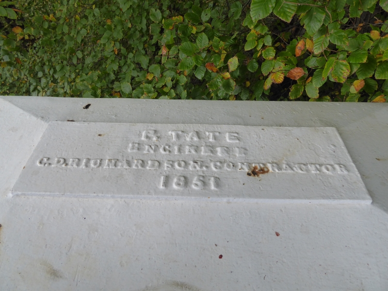
Corby Beck Quarries. Cast iron footbridge with wooden plank walkway, added at
parapet level to the north face in 1851: P. Tate engineer and C.D. Richardson,
contractor. 2 piers in river bed and 2 on either bank, giving 5 semicircular
arches of 27 metre spans, formed of large blocks of dressed stone with
channelled joints and voussoirs: parapet of 1½ metres height, giving a total
height from the summer level of the river of 33 metres: width to give double
track and a total length of 280 metres. A major and early railway viaduct,
forming an important landscape feature in an area of outstanding natural
beauty. Includes a footbridge with cast inscribed plate at the east end:
foundation stones built into either side of the parapet at the west end and
centrally placed stone inscribed with the engineer and builder: N.E.R. gas lamp
bracket at west end (lamp missing) and central bracket (lamp missing) to light
footbridge: also railings on parapet of south side.
Listing NGR: NY4686454660
External links are from the relevant listing authority and, where applicable, Wikidata. Wikidata IDs may be related buildings as well as this specific building. If you want to add or update a link, you will need to do so by editing the Wikidata entry.


Other nearby listed buildings
