Approximate Location Map
Large Map »
Latitude: 55.9686 / 55°58'6"N
Longitude: -2.7221 / 2°43'19"W
OS Eastings: 355024
OS Northings: 675300
OS Grid: NT550753
Mapcode National: GBR 2V.WSH9
Mapcode Global: WH7TZ.570R
Plus Code: 9C7VX79H+C5
Entry Name: Sandy's Mill
Listing Name: Sandy's Mill
Listing Date: 5 February 1971
Category: A
Source: Historic Scotland
Source ID: 347884
Historic Scotland Designation Reference: LB14519
Building Class: Cultural
ID on this website: 200347884
Location: Prestonkirk
County: East Lothian
Electoral Ward: Haddington and Lammermuir
Parish: Prestonkirk
Traditional County: East Lothian
Tagged with: Watermill
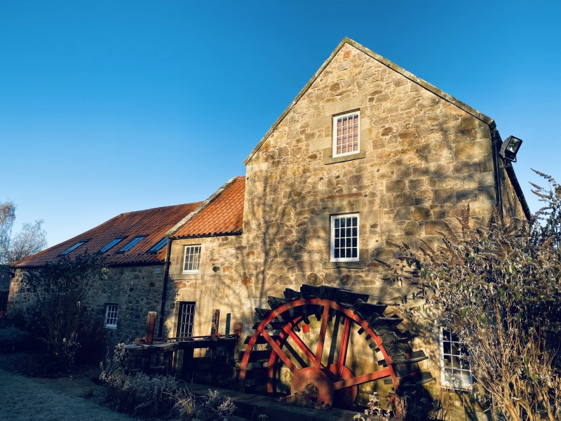
Mid-late 18th century. 3-storey meal-mill, roughly
rectangular in plan with later single storey threshing
mill abutting to W. Random rubble with stugged ashlar
dressings.
N ELEVATION: entrance at ground floor, with further 1st
floor doorway above. Window to 2nd floor. Kiln to right
with small opening to centre below eaves.
S ELEVATION: noteworthy low breastshot waterwheel to
main block, measuring 426cm (outside diameter) by 150cm
(width) originally with 30 wooden paddles each 3cm
thick. Window at 1st and 2nd floor. Gabled 2-storey
single bay and single storey piend-roofed threshing mill
butt joined to W.
Red pantiles to mill, threshing mill and to steep
truncated pyramidal roof of kiln (ventilator missing).
INTERIOR: much of machinery survives; waterwheel drove
2 pairs of millstones, one for grinding, the other for
shelling. A grain bruiser, pearl barley wheel and
gearing also remain. The sack hoist is of interest;
could be operated from any floor, has a dog clutch and
automatic and manual disengaging device.
Kiln floor is 30cm below 2nd floor level of the mill;
constructed of cast-iron perforated plates. Single
bagging outlet from kiln floor to mill. Access to kiln
firebox external; internal route blocked.
Existing mill probably built on the site of former mill
to serve the Gilmerton estate; mill buildings appear on
Forrest map 1799. Wheel drive unusual; as is the
absence of shaking conveyors and bucket elevators.
Milling ceased by early 1940s, waterwheel pit now silted
and the lade diverted to power a generator. Mill and
accompanying cottages recently sold; proposals made for
restoration (1989).
External links are from the relevant listing authority and, where applicable, Wikidata. Wikidata IDs may be related buildings as well as this specific building. If you want to add or update a link, you will need to do so by editing the Wikidata entry.


Other nearby listed buildings
