Approximate Location Map
Large Map »
Latitude: 55.9278 / 55°55'40"N
Longitude: -2.9975 / 2°59'51"W
OS Eastings: 337769
OS Northings: 670978
OS Grid: NT377709
Mapcode National: GBR 2H.ZJKB
Mapcode Global: WH7V0.X8SH
Plus Code: 9C7VW2H2+4X
Entry Name: Falside Castle
Listing Name: Falside Castle with Outbuilding and Retaining Walls
Listing Date: 5 February 1971
Category: B
Source: Historic Scotland
Source ID: 353331
Historic Scotland Designation Reference: LB19070
Building Class: Cultural
ID on this website: 200353331
Location: Tranent
County: East Lothian
Electoral Ward: Tranent, Wallyford and Macmerry
Parish: Tranent
Traditional County: East Lothian
Tagged with: Castle
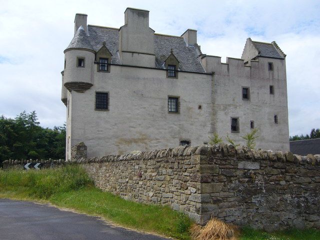
15th century 4-storey keep, enlarged into mansion with L-plan addition to S in 16th century; substantially restored, Ian S Parsons, 1982-5; D H Moran, builder. Various windows re-opened and others inserted in course of restoration, in sympathetic manner. Sited on high ground (Falside Hill). Freestone rubble, partly coursed in earlier work, with oyster shell pinning; ashlar dresing repairs and brick rebuilding with white harling 1982-5.
15TH CENTURY KEEP: rectangular-plan, circa 30 x 39 feet. 4th storey vaulted. Crenellated parapet walk to wallhead and crowstepped, gabled cap-house to NE angle. Round arched doorway in N elevation. Minimum of openings at ground, irregularly placed arrow slit windows and fewer larger windows in upper floors, some altered in 17th century, bearing backset margins and chamfered arrises.
INTERIOR: mural stair leading to 1st floor to left of door, turnpike above 1st floor; pit dungeon; flagstones; stone corbels retained.
16TH CENTURY ADDITION: to S elevation of keep. Relieving arches to windows; quirk-edged roll mouldings. Door in W elevation (surround renewed, 1982) with square panel above. Chamfered angle to SW, corbelled to square above. Round tower set in re-entrant angle, mitred above ground floor on rectangular base. S elevation symmetrical; crowstepped, gabled centre bay with window to each of 3 upper floors
and gablehead stack; borbelled angle turrets with candle-snuffer roofs. Sizeable set-off wallhead stack to E elevation, flanked by windows breaking eaves in modern gabled dormerheads, 1 dated 1982, 1 bearing initials TMC CHH. 2 further such gabled dormerheads to W elevations.
INTERIOR: not seen (1989).
Multi-pane glazing patterns. Grey slates.
OUTBUILDING: rectangular plan, single storey, gabled outbuilding, sited to N of castle; freestone rubble; much altered, with red and grey corrugated sheet metal roof.
RETAINING WALL: largely renewed, 1982. Freestone rubble with rubble coping, adjoined to castle.
Built by the Fawside family and known over the centuries as Faswside, Fallside and Fa'side. The Battle of Pinkie was fought on the fields below. A 17th century house formerly stood closeby to SE. Restored for T M Craig, from 1982.
External links are from the relevant listing authority and, where applicable, Wikidata. Wikidata IDs may be related buildings as well as this specific building. If you want to add or update a link, you will need to do so by editing the Wikidata entry.


Other nearby listed buildings
