Approximate Location Map
Large Map »
Latitude: 55.8608 / 55°51'38"N
Longitude: -3.0824 / 3°4'56"W
OS Eastings: 332345
OS Northings: 663595
OS Grid: NT323635
Mapcode National: GBR 60XN.GX
Mapcode Global: WH6T1.MYCF
Plus Code: 9C7RVW69+82
Entry Name: Dalhousie Castle
Listing Name: Dalhousie Castle
Listing Date: 22 January 1971
Category: A
Source: Historic Scotland
Source ID: 331209
Historic Scotland Designation Reference: LB784
Building Class: Cultural
ID on this website: 200331209
Location: Cockpen
County: Midlothian
Electoral Ward: Midlothian South
Parish: Cockpen
Traditional County: Midlothian
Tagged with: Castle
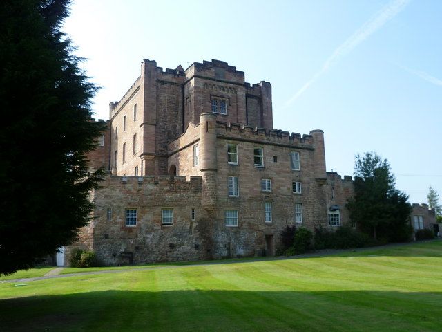
Circa 1450. L-plan keep and curtain wall, incorporated with new buildings circa 1633, alterations by John Douglas and George Paterson in 18th century, additions and castellations by William Burn, 1825. Various storeys, basement. Tooled, coursed pink sandstone with droved dressings. Crenellated parapets; angle turrets.
W (PRINCIPAL) ELEVATION: asymmetrical; entrance bay advanced to centre of former curtain wall, round-arched doorway with recessed panelled and glazed timber door, 2 tall vertical openings above formerly for beams of drawbridge, Ramsay family crest on tooled panel between openings; single bay link to 2-storey drum tower flanking to left with round-arched irregularly placed windows and watchtower; 3-storey, 6-bay curtain wall to right of entrance bay with angle turrets through 1st and 2nd floors, regular fenestration added in 1633, hoodmoulds to centre 4 bays at ground and 1st floors, tooled pediments to windows to left of 1st floor reading "WED" (William Earl of Dalhousie) and "MCD" (Margaret Countess of Dalhousie); keep predominantly obscured by additions to curtain wall.
S ELEVATION: asymmetrical; 4-storey with vaulted cellars below; 4-bay; coped battered wall advanced at basement; bay to left advanced with Y-traceried window to ground floor, 5-light window to 1st floor and regular fenestration to 2nd and 3rd floors; canted 2-storey bay to re-entrant angle to right, window to right return; single storey block advanced to ground floor with square-plan block to right angle; regular fenestration recessed 1st, 2nd and 3rd floors.
E ELEVATION: near-symmetrical; 3-storey, 3-bay block to centre with boarded timber door to basement and irregular fenestration to remainder, angle turrets through 1st and 2nd floors; 4-storey 15th century keep predominantly obscured, bay advanced to centre with bipartite round-arched window with hoodmould to 4th floor, windows to left and right returns and flanking bay to right; single storey block flanking to left with regular fenestration; 2-storey block flanking to right, round-arched window to ground floor with 2 corbel stones below; narrow round-arched window above surmounted by tooled panel bearing Ramsay crest; single storey block to outer right with doorway to left flanked by 3 windows to right.
N ELEVATION: asymmetrical; 6-bay; single storey wall advanced to outer left enclosing small courtyard, 2 2-leaf segmentally-arched boarded timber doors; 2-storey block behind. Single storey and basement block to right with regular fenestration; 2-storey block slightly recessed behind with 3-storey tower to left, 3-slight window to 1st and 2nd floors, 2-light window to flanking bays to right; 4-storey 15th century keep recessed behind, irregular fenestration; drum tower to outer right (see above).
Variety of timber-framed windows. Piended 18th century grey slate roof with lead ridges. Variety of gablehead, wallhead and ridge stacks. Cast-iron rainwater goods.
INTERIOR: much altered. Barrel vaulted cellars to keep. Gothick entrance hall by William Burn with imperial staircase leading to mezzanine floor, fan-vaulted plaster ceiling with 2 circular inset lanterns; reception rooms to south including dining room with decorative timber ceiling, drawing room with Jacobean plaster ceiling and library with Gothick bookcases and elaborate rococo ceiling; simple barrel vaulted chapel (originally an armoury). Redecorated by Morison and Co in 1875; refitted in 1972 by Mottram, Patrick, Whitehorn, Dalgleish & Partners.
B Group with Folly on W Bank of River South Esk, Folly on E Bank of River South Esk, Dalhousie Bridge over River South Esk, West Lodge and Grove Farm (former Dalhousie Walled Garden). Dalhousie Castle was described by Groome as "a stately castellated pile" (p335). Simon de Ramsay was granted the barony of Dalhousie, then "Dalwolsie" (meaning Vale of Wool), in the early 12th century, and George Ramsay was created Lord Ramsay in 1618. William, 2nd Lord, became the Earl of Dalhousie in 1633, converting the castle into a renaissance mansion and leaving his initials and those of his wife in the pediments on the W Elevation. The castle, which originally comprised of a keep and curtain wall surrounded by a dry moat (now filled in), is built of pink sandstone which is thought to have come from the adjacent quarry (now disused). Over the centuries the castle has been much altered. The castle was also Geogianised by George Paterson between 1778 and 1779. According to Sir Walter Scott "the old Castle of Dalhousie...was mangled by a fellow called, I believe, Douglas, who destroyed, as far as in him lay, its military and baronial character, and roofed it after the fashion of a poor's-house. Burn is now restoring and repairing in the old taste" (Journal for 23 December 1827). William Burn restored the mullion and transomed windows, the gothic interiors and also castellated the curtain wall. In 1867 the upper storey of the castle was lost to fire, but has been restored. Between 1927 and 1950 it was used as a prep-school for boys, in 1955 it became an hotel for the accommodation and entertainment of Canadian visitors from the Dalhousie College in Canada, and in 1985 it became an hotel. The grounds, which had open areas of sweeping curved woodland, illustrated by Nasmyth and described in the NSA as "singularly beautiful", were laid out by James Robertson before 1750, and were referred to by J.C. Loudon as having an "extensive collection of trees and shrubs", the landscape was altered in the mid 19th century.
External links are from the relevant listing authority and, where applicable, Wikidata. Wikidata IDs may be related buildings as well as this specific building. If you want to add or update a link, you will need to do so by editing the Wikidata entry.


Other nearby listed buildings
