Approximate Location Map
Large Map »
Latitude: 52.0095 / 52°0'34"N
Longitude: -3.8052 / 3°48'18"W
OS Eastings: 276196
OS Northings: 236102
OS Grid: SN761361
Mapcode National: GBR Y4.HDT4
Mapcode Global: VH5DX.0R6C
Plus Code: 9C4R255V+RW
Entry Name: Pont Dolauhirion (partly in Cilycwm community)
Listing Date: 8 March 1966
Last Amended: 18 June 2004
Grade: I
Source: Cadw
Source ID: 10964
Building Class: Transport
Also known as: Pont Dolauhirion
ID on this website: 300010964
Location: Situated some 1.5km of Llandovery, carrying road to Cilycwm and Porthrhyd across River Tywi.
County: Carmarthenshire
Community: Llandovery (Llanymddyfri)
Community: Llandovery
Locality: Dolauhirion
Traditional County: Carmarthenshire
Tagged with: Road bridge
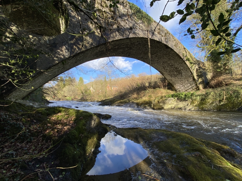
Road bridge across the Tywi, built in 1773 by Thomas Edwards, and one of the outstanding surviving works of the bridge-building Edwards family of Pontypridd. This bridge has the weight-reducing pierced spandrels that Thomas' father the Rev William Edwards introduced at Pontypridd in 1756, one of the very few post-Roman advances in masonry bridge building. This is perhaps one of the most elegant of the surviving Edwards bridges, the very broad elliptical arch rising to a thin crown. Although marked 'Thomas Edward 1773', the bridge was attributed by Thomas Rees writing in 1815 and Samuel Lewis in 1833 to William Edwards, and A Arber-Cooke records that it has also been dated 1785.
Road bridge, rubble stone single arch of some 25m span and 3.6m width rising high above the Tywi from natural rock abutments. The single broad elliptical arch has large cut stone voussoirs, and the spandrels have masonry in very thin courses and are pierced with large circular holes also with cut stone voussoirs. The abutments are stepped out slightly and splayed. Humped roadway with ramped parapets of rather cruder masonry than the bridge, with stone slab coping stones. In centre of S parapet a slate coping stone marked 'Thomas Edward 1773'.
Included at Grade I as an outstanding example of the revolutionary bridge designs evolved by the Rev. William Edwards and his sons in the later C18.
Scheduled Ancient Monument: CM005
External links are from the relevant listing authority and, where applicable, Wikidata. Wikidata IDs may be related buildings as well as this specific building. If you want to add or update a link, you will need to do so by editing the Wikidata entry.


Other nearby listed buildings
