Approximate Location Map
Large Map »
Latitude: 51.5668 / 51°34'0"N
Longitude: -3.9711 / 3°58'15"W
OS Eastings: 263481
OS Northings: 187167
OS Grid: SS634871
Mapcode National: GBR GX.Y4NH
Mapcode Global: VH4KH.4W08
Plus Code: 9C3RH28H+PH
Entry Name: Mumbles Lighthouse
Listing Date: 24 June 1986
Last Amended: 29 October 1999
Grade: II*
Source: Cadw
Source ID: 11721
Building Class: Maritime
Also known as: Goleudy Mwmbwls
ID on this website: 300011721
Location: Situated on an exposed rocky tidal islet at Mumbles Head.
County: Swansea
Town: Swansea
Community: Mumbles (Y Mwmbwls)
Community: Mumbles
Locality: Mumbles Head
Traditional County: Glamorgan
Tagged with: Lighthouse
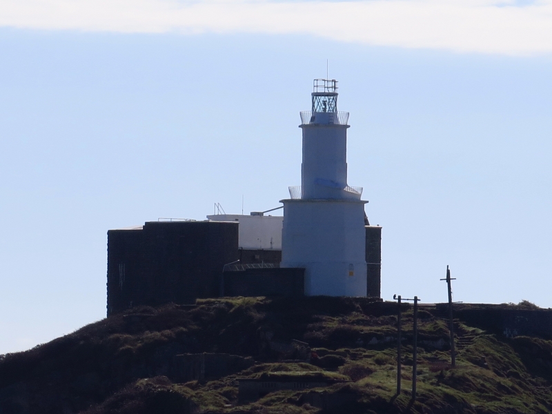
The lighthouse was built as a warning light on the outer of 2 tidal islands off Mumbles Head at the entrance to Swansea Bay. A light was established here by Act of Parliament in 1791, but the first lighthouse, designed by the harbour surveyor, collapsed before completion, and in 1793, William Jernegan, architect, of Swansea, was appointed to design a replacement for the Harbour Trustees. Originally using two coal-fired lights, the lighthouse was converted to a single oil-lit lantern in 1798. In 1834 the lighthouse was taken over by Trinity House, and at some time the lantern was replaced, possibly in 1860, by a dioptric light in a 10-sided lantern. In 1905, a new occulting light was fitted and a new optic was installed in 1972. New railings (based on an earlier design) were also fitted. In 1995 the lighthouse was converted to solar power operation, with solar module arrays being mounted in frames on the adjacent battery roof.
An octagonal lighthouse of coursed rubble stone painted white. The tower is stepped and double-skinned, as the inner tower rises to a greater height than the outer. The outer tower is 8.5m high and slightly stepped to form 3 stages. An arched doorway with plaque over it inscribed ''MDCCXCIII Wm Jernegan arch''. At the top of the outer tower is a projecting platform with bellied cast-iron rails, originally to accommodate a fire-basket. The inner tower rises a further 6m and terminates in a cast-iron octagonal lantern with lattice glazing. This lantern is a recent replacement. A projecting cast-iron gallery with a bellied rail was cast at Neath Abbey Foundry in 1798.
The lighthouse is enclosed on 3 sides by a battery.
The narrow inner tower has a staircase with cast iron hand rail in the upper stage only, giving access to interior of the lantern. The lower stage has an open central well originally used in the haulage of coal to the 2 lanterns. The main staircase leading to the lower platform occupies the vaulted space between the outer and inner towers; the roof over the exposed section of this staircase as it continues above the middle gallery is recent.
Listed grade II* as an exceptionally interesting and unusual design of lighthouse, which retains many of the structural features associated with a coal-fired light.
External links are from the relevant listing authority and, where applicable, Wikidata. Wikidata IDs may be related buildings as well as this specific building. If you want to add or update a link, you will need to do so by editing the Wikidata entry.


Other nearby listed buildings
