Approximate Location Map
Large Map »
Latitude: 53.2989 / 53°17'55"N
Longitude: -4.6285 / 4°37'42"W
OS Eastings: 224928
OS Northings: 381211
OS Grid: SH249812
Mapcode National: GBR GMYZ.GMC
Mapcode Global: WH31B.WB3W
Plus Code: 9C5Q79XC+GH
Entry Name: Ebenezer Chapel
Listing Date: 25 July 1994
Last Amended: 25 July 1994
Grade: II
Source: Cadw
Source ID: 14733
Building Class: Religious, Ritual and Funerary
Also known as: Ebenezer Chapel
ID on this website: 300014733
Location: Approximately 100m S of junction with Cytir Road. Behind low wall with stone posts, iron railings and gates.
County: Isle of Anglesey
Community: Holyhead (Caergybi)
Community: Holyhead
Built-Up Area: Holyhead
Traditional County: Anglesey
Tagged with: Chapel
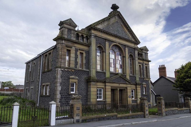
Late C19 chapel.
Grey stone front with bathstone dressings, pebbledashed side and rear, slate roof. Pedimented ‘temple’ front with elaborate finial. Four Doric pilasters; central bay has large round arched window with paired lights, smaller single light windows to outer bays. Channelled bathstone stone ground floor with paired entrance doors, pediment over, square-headed windows to sides. Plaque from earlier chapel on site ‘Ebenezer 1850 MC’. Outer bays of front have scrolls flanking pediment over 3-arched arcade, tabernacle to ends; below this 2 windows, single window to ground floor in bathstone architrave; outer bay returns (which project as stair turrets) have 2 paired windows to each floor in bathstone surrounds. Four bays to sides, first floor round-headed windows, ground floor square-headed (sash glazing with marginal bars). Gable end to W has no openings.
[To R of chapel, attached gabled school, rendered, slate roofs.]
Included for architectural qualities of main front.
External links are from the relevant listing authority and, where applicable, Wikidata. Wikidata IDs may be related buildings as well as this specific building. If you want to add or update a link, you will need to do so by editing the Wikidata entry.


Other nearby listed buildings
