Approximate Location Map
Large Map »
Latitude: 52.2679 / 52°16'4"N
Longitude: -3.5772 / 3°34'37"W
OS Eastings: 292471
OS Northings: 264475
OS Grid: SN924644
Mapcode National: GBR 9F.Z9XV
Mapcode Global: VH5CV.Y888
Plus Code: 9C4R7C9F+54
Entry Name: Caban Coch Dam (partly in the community of Llanwrthwl, Brecon District)
Listing Date: 31 July 1995
Last Amended: 31 July 1995
Grade: II*
Source: Cadw
Source ID: 16202
Building Class: Water Supply and Drainage
ID on this website: 300016202
Location: About 6km SW of Rhayader centre.
County: Powys
Community: Rhayader (Rhaeadr Gwy)
Community: Rhayader
Locality: Elan Valley
Traditional County: Radnorshire
Tagged with: Dam
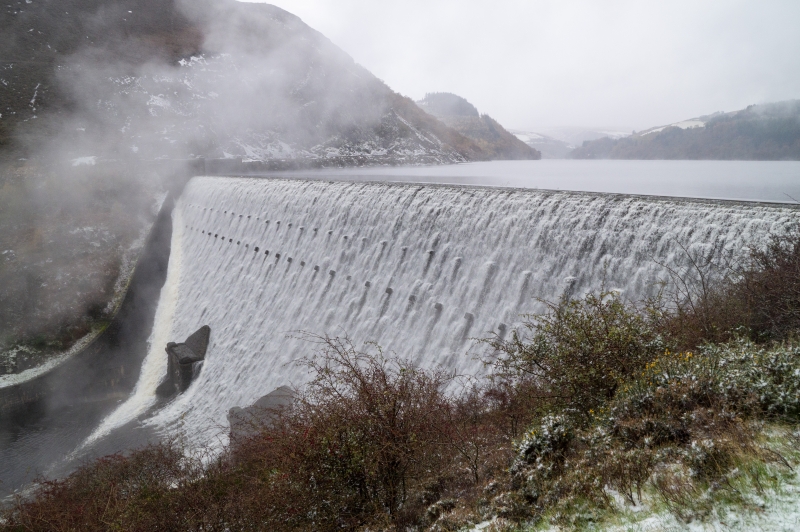
One of series of dams in Elan Valley built by City of Birmingham 1893 to 1904. Engineer James Mansergh. The scheme was amongst the greatest civic achievements of the late C19. The Corporation of Birmingham employed direct labour for the scheme which involved the construction of 53 km of railway to transport materials from the Wye Valley line at Rhayader, 4 dams, an aqueduct 126 km long, and a village for construction workers. The height of the reservoirs enabled water to reach the outskirts of Birmingham by gravity alone, without the expense of pumping. Provision was made for future expansion in the Claerwen Valley where the scheme was brought to its current state by the Claerwen dam in 1952.
Bronze plaque from dam (removed to visitor centre) says
" Caban Coch Reservoir
Total Capacity 8,000,000,000 gallons
Top Water Area 500 Acres
Top Water Level 822 feet above Ordnance Datum
Height of Dam above River Bed 122 ft
Depth of Foundations below River Bed 25 ft
Length of Weir 566 ft
Thickness of Dam at Base 122 ft 6 in
Estimated quantity of masonry 144,800 cubic yards"
Masonry dam with massive heavily rock-faced blocks. To ends, spillways with parapet walls, spillways broaden as they drop, walls turning to become parallel with stream. Two rows of protruding blocks (used to support scaffolding during construction). At bottom of dam, two massive circular outlets with keyblock set in surrounds with piers to ends and pyramidal pediment with tumbled blocks. To each end of dam, platform with gigantic capstones worked to resemble natural rock; steps down to top of dam, arches to reservoir side, 3 windows towards dam, square outlet to spillway.
Graded II* as part of one of the greatest civil engineering projects of C19.
External links are from the relevant listing authority and, where applicable, Wikidata. Wikidata IDs may be related buildings as well as this specific building. If you want to add or update a link, you will need to do so by editing the Wikidata entry.


Other nearby listed buildings
