History in Structure

The Forge

A Grade II Listed Building in Glasbury, Powys

More Photos »
Approximate Location Map
Large Map »

Coordinates

Latitude: 52.0456 / 52°2'44"N

Longitude: -3.2725 / 3°16'20"W

OS Eastings: 312829

OS Northings: 239343

OS Grid: SO128393

Mapcode National: GBR YV.F6WY

Mapcode Global: VH6BG.7VB6

Plus Code: 9C4R2PWH+62

Entry Name: The Forge

Listing Date: 18 January 1996

Last Amended: 18 January 1996

Grade: II

Source: Cadw

Source ID: 17184

Building Class: Domestic

ID on this website: 300017184

Location: Located on the perimeter road around Boughrood Churchyard, N of the church.

County: Powys

Community: Glasbury (Y Clas-ar-wy)

Community: Glasbury

Locality: Boughrood

Traditional County: Radnorshire

Tagged with: Cottage

Find accommodation in
Llanstephan

Exterior

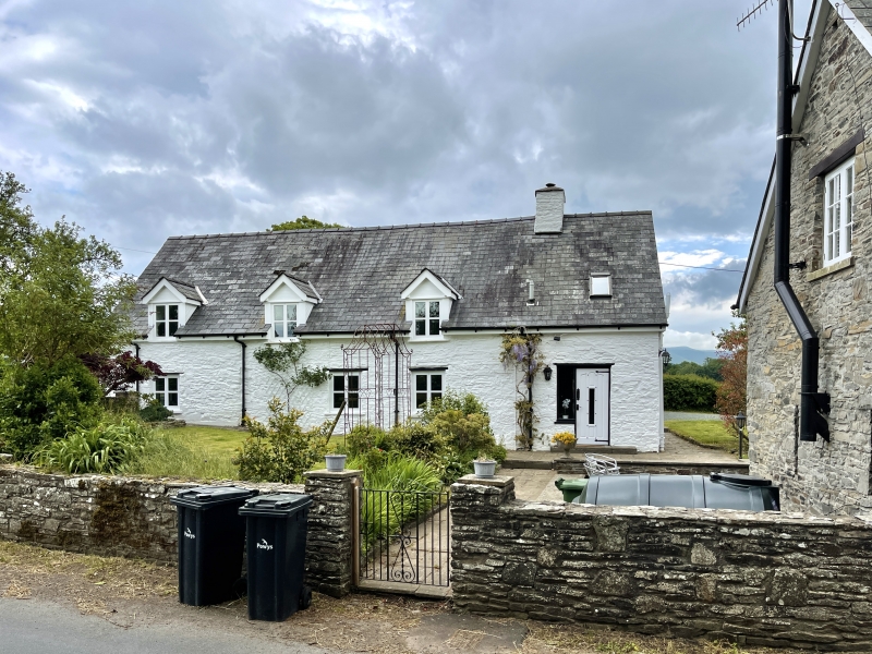
Cottage of the C16-C17, altered in the C19, when the adjacent blacksmith's forge was in operation. Whitewashed stone with a slate roof. One storey and attic, 3 bays, with a lean-to at the SW end. C19 casement windows with timber lintels, and 3 raised and gabled dormers with casement windows on each side, one at the NE end of the NW side added in the later C20. The SE elevation has larger windows and lean-to conservatory. Wall partially battered. Entrance now through lean-to to door at side of the gable stack.

Interior

Gable entrance at the side of stack with heavy chamfered fire beam extending and slightly arched over a cupboard or early stair on left. Chamfered cross beams. Timber-framed partition built into pair of raised crucks, which have half-dovetails for the tie and collar beams, both now removed. Vertically abutted apex notched for diagonally set ridge.

Reasons for Listing

Included as one of the best surviving examples of the sub-medieval cruck-built houses placed around the churchyard at Boughrood.

External Links

External links are from the relevant listing authority and, where applicable, Wikidata. Wikidata IDs may be related buildings as well as this specific building. If you want to add or update a link, you will need to do so by editing the Wikidata entry.

Recommended Books

Other nearby listed buildings

  • II Bier House at Church of St Cynog
    At the northern corner of the churchyard within the centre of the small village of Boughrood.
  • II Church of St Cynog
    The church is located near the centre of a large circular graveyard, at the centre of the small village of Boughrood.
  • II Barn and cowhouse range formerly with Village Farm
    Located on the SE side of the perimeter road around the circular graveyard of Boughrood Church, approximately 200m from the church building, and forming the NW and NE side of the farm yard behind Vil
  • II Village Farmhouse
    Located on the SE side of the perimeter road around the circular graveyard of Boughrood Church, approximately 200m from the church building.
  • II* Boughrood Cottage
    Located 100m to the NW of Boughrood church across a small tributary of the River Wye, within its own grounds, and with its farmyard, buildings and mill to the N.
  • II* Boughrood Court
    Located 100m to the NW of Boughrood church across a small tributary of the River Wye, within its own grounds, and with its farmyard, buildings and mill to the N.
  • II Neuadd
    Located on the right bank of a small tributary of the River Wye, approximately 250m from Boughrood Church.
  • II Boughrood Castle
    Located E of Boughrood church, and S of the medieval castle site at Castle Farm, and approached by a driveway from the Boughrood to Glasbury Road.

BritishListedBuildings.co.uk is an independent online resource and is not associated with any government department. All government data published here is used under licence. Please do not contact BritishListedBuildings.co.uk for any queries related to any individual listed building, planning permission related to listed buildings or the listing process itself.

British Listed Buildings is a Good Stuff website.