Approximate Location Map
Large Map »
Latitude: 52.9871 / 52°59'13"N
Longitude: -3.0433 / 3°2'35"W
OS Eastings: 330061
OS Northings: 343820
OS Grid: SJ300438
Mapcode National: GBR 73.HZ48
Mapcode Global: WH89B.752T
Plus Code: 9C4RXXP4+VM
Entry Name: Ruabon Railway Station
Listing Date: 24 February 1983
Last Amended: 22 February 1995
Grade: II
Source: Cadw
Source ID: 1719
Building Class: Transport
Also known as: Ruabon Railway Station, Station Approach (N End) Ruabon
ID on this website: 300001719
Location: Situated off Bridge Street to the W of the town centre.
County: Wrexham
Community: Ruabon (Rhiwabon)
Community: Ruabon
Built-Up Area: Ruabon
Traditional County: Denbighshire
Tagged with: Railway station
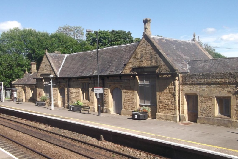
Designed by Henry Robertson in the 1860s replacing the original Shrewsbury and Chester Railway Station by T M Penson. Converted to offices late C20 and platform canopy removed.
Tudor-Gothic Revival style, single storey. Sandstone ashlar with rusticated quoins, slate roof, stone chimneys. Elevation to road: projecting gabled wings to each end with stone copings and finials. Each has a tall mullioned and transomed window, partially blocked. Central range has central mullioned and transomed window, and a doorway on each side with Tudor-arch head and dimpled spandrels. Low ranges with end stack set back and attached to left and right. Similar platform elevation: low flanking ranges have blocked entrances and windows, other openings blocked, cast-iron gutter with shaped brackets and cast-iron rainwater goods.
Listed for its special interest as good example of an 1860s station in a style popular for rural railway architecture.
External links are from the relevant listing authority and, where applicable, Wikidata. Wikidata IDs may be related buildings as well as this specific building. If you want to add or update a link, you will need to do so by editing the Wikidata entry.


Other nearby listed buildings
