History in Structure

Bryn Ysgol

A Grade II Listed Building in Ysbyty Ifan, Conwy

More Photos »
Approximate Location Map
Large Map »

Coordinates

Latitude: 53.0237 / 53°1'25"N

Longitude: -3.7291 / 3°43'44"W

OS Eastings: 284123

OS Northings: 348774

OS Grid: SH841487

Mapcode National: GBR 67.FDNL

Mapcode Global: WH66J.P8GB

Plus Code: 9C5R27FC+F9

Entry Name: Bryn Ysgol

Listing Date: 8 April 1997

Last Amended: 8 April 1997

Grade: II

Source: Cadw

Source ID: 18324

Building Class: Domestic

ID on this website: 300018324

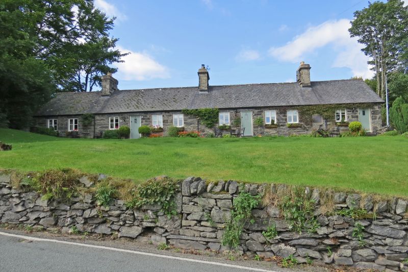
Location: Sited commandingly on a hillslope at the western edge of the village; set back from the road and raised up on a revetted bank.

County: Conwy

Community: Ysbyty Ifan

Community: Ysbyty Ifan

Traditional County: Caernarfonshire

Tagged with: Building

Find accommodation in
Yspytty-Ifan

History

An almshouse complex was originally erected in Tir Ifan in 1709 by the will of Captain Richard Vaughan of Pant Glas, a blind Royalist veteran of the civil wars and one of the Poor Knights of Windsor. He also gave `the use of two hundred pounds for ever to maintain six poor aged men of this parish.' These almshouses were in due course superseded by a new range, built by Mrs Catherine Vaughan of Pant Glas, presumably in the late C18 and form the core of the present range. The original almshouses (of Captain Vaughan's foundation) were dissolved by the Charity Commissioners and sold, being subsequently demolished in 1885. In 1880, using the transfered endowment and the proceeds of the sale of these, Edward Gordon, Baron Penrhyn, rebuilt Mrs Vaughan's range and gave it its present appearance.

Reasons for Listing

Listed for its special historic interest as a C19 range of almshouses in a commanding location above the village.

External Links

External links are from the relevant listing authority and, where applicable, Wikidata. Wikidata IDs may be related buildings as well as this specific building. If you want to add or update a link, you will need to do so by editing the Wikidata entry.

Recommended Books

Other nearby listed buildings

  • II Bryn Ysgol
    Sited commandingly on a hillslope at the western edge of the village; set back from the road and raised up on a revetted bank.
  • II Bryn Ysgol
    Sited commandingly on a hillslope at the western edge of the village; set back from the road and raised up on a revetted bank.
  • II Former Wheelwright's Workshop.
    Set into a slight slope immediately S of the village crossroads, adjacent to the former corn mill.
  • II Bryn Ffynnon
    Located some 30m S of the Pont Ysbyty Ifan on the W bank of the river Conwy and centrally-placed within an arc of three estate terraces, rubble-walled and gated forecourt.
  • II Bryn Ffynnon
    Located some 30m S of the Pont Ysbyty Ifan on the W bank of the river Conwy and centrally-placed within an arc of three estate terraces, rubble-walled and gated forecourt.
  • II Bryn Ffynnon
    Located some 30m S of the Pont Ysbyty Ifan on the W bank of the river Conwy and centrally-placed within an arc of three estate terraces, rubble-walled and gated forecourt.
  • II 4, Mill Street, Ysbyty Ifan
    Facing the river Conwy on its W bank in the centre of the village; immediately SW of the Pont Ysbyty Ifan, rubble-walled and gated forecourt.
  • II Former Drying Houses
    Located at the bottom of a slope, 50m E of the road, diagonally behind Mill Street; set against the incline.

BritishListedBuildings.co.uk is an independent online resource and is not associated with any government department. All government data published here is used under licence. Please do not contact BritishListedBuildings.co.uk for any queries related to any individual listed building, planning permission related to listed buildings or the listing process itself.

British Listed Buildings is a Good Stuff website.