History in Structure

Bridge over Afon Cadnant

A Grade II Listed Building in Menai Bridge, Isle of Anglesey

More Photos »
Approximate Location Map
Large Map »

Coordinates

Latitude: 53.2337 / 53°14'1"N

Longitude: -4.1584 / 4°9'30"W

OS Eastings: 256036

OS Northings: 372910

OS Grid: SH560729

Mapcode National: GBR 5N.0BBC

Mapcode Global: WH541.3Z3D

Plus Code: 9C5Q6RMR+FM

Entry Name: Bridge over Afon Cadnant

Listing Date: 18 July 1997

Last Amended: 18 July 1997

Grade: II

Source: Cadw

Source ID: 18565

Building Class: Transport

Also known as: Bridge over Afon Cadnant (partly in Menai Bridge community)

ID on this website: 300018565

Location: Located at the mouth of the Afon Cadnant, where it runs into the Menai Strait.

County: Isle of Anglesey

Town: Menai Bridge

Community: Menai Bridge (Porthaethwy)

Community: Menai Bridge

Locality: Cwm Cadnant

Built-Up Area: Menai Bridge

Traditional County: Anglesey

Tagged with: Bridge Road bridge

Find accommodation in
Llandegfan

History

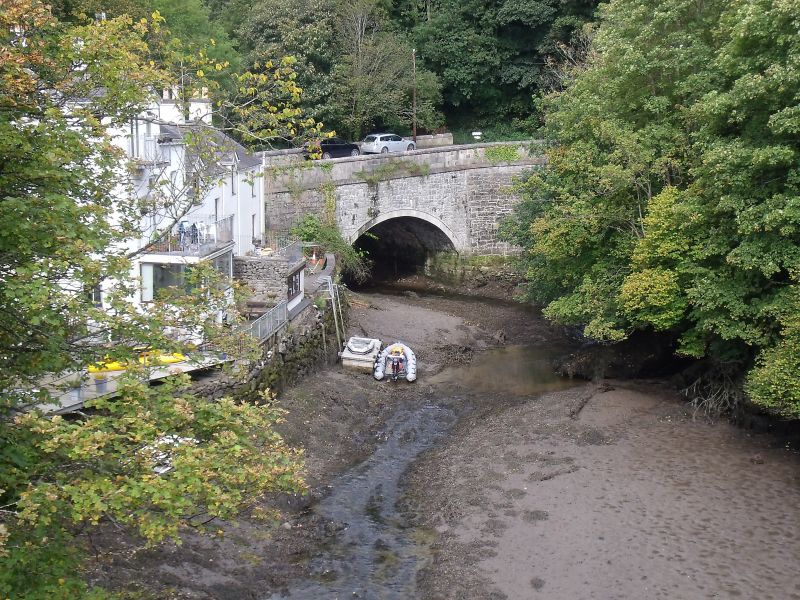
In 1805 Viscount Thomas James Warren Bulkeley, (7th Viscount) made a new road through his own land to run alongside the Straits. The county was asked to pay for a bridge over Afon Cadnant. The road was opened in 1806. The road was later turned into a turnpike in 1828 and the bridge continued to be used as part of the main route between Menai Bridge and Beaumaris until a new bridge was built over the Afon Cadnant in 1973. This by-passes the old bridge, though it may still be crossed and is used when repairs are being made to the newer bridge.

Exterior

Single span segmentally arched bridge of coursed and squared granite with buttresses either side of the span. The parapets have been raised or rebuilt at a later date.

Reasons for Listing

Listed as a well-preserved example of an early C19 masonry bridge which is of particular historical interest in the context of early C19 improvements to transport on the island.

External Links

External links are from the relevant listing authority and, where applicable, Wikidata. Wikidata IDs may be related buildings as well as this specific building. If you want to add or update a link, you will need to do so by editing the Wikidata entry.

Recommended Books

Other nearby listed buildings

  • II Bridge over Afon Cadnant (partly in Menai Bridge community)
    Located at the mouth of the Afon Cadnant, where it runs into the Menai Strait.
  • II Nant Cottage
    Set alongside the N side of the A545 Beaumaris Road out of Menai Bridge; to the E side of the Afon Cadnant where it joins the Menai Strait.
  • II Plas Cadnant
    Set within grounds in an elevated location on W bank of Afon Cadnant. Reached by private driveway, off the Cadnant Road, W of the bridge. Parkland to NW and walled garden to NE.
  • II Plas Cadnant Icehouse
    Located in a field c50m SW of Plas Cadnant.
  • II Plas Cadnant domestic service outbuilding and wall
    Behind Plas Cadnant house, forming one side of an enclosed service yard together with a high wall one side, with a lean-to range attached, and tall iron gates. The other side of the yard is defined by
  • II Y Craig Wen
    Set back from the road in an elevated position overlooking the Menai Strait, N of the town centre and reached by a private driveway.
  • II Bron Menai
    Located on the east side of Cadnant Road, to N of town centre, the rear of the house directly overlooks the Menai Strait.
  • II Boat-house at Craig-y-Don
    Set back from the SE side of the A545 Beaumaris Road. The boat-house is located at the foreshore of the Menai Straits to SW of the coach-house and stables.

BritishListedBuildings.co.uk is an independent online resource and is not associated with any government department. All government data published here is used under licence. Please do not contact BritishListedBuildings.co.uk for any queries related to any individual listed building, planning permission related to listed buildings or the listing process itself.

British Listed Buildings is a Good Stuff website.