Approximate Location Map
Large Map »
Latitude: 51.9268 / 51°55'36"N
Longitude: -2.889 / 2°53'20"W
OS Eastings: 338967
OS Northings: 225743
OS Grid: SO389257
Mapcode National: GBR FC.NS01
Mapcode Global: VH78P.WT2R
Plus Code: 9C3VW4G6+PC
Entry Name: Church of St James
Listing Date: 9 January 1956
Last Amended: 19 October 2000
Grade: II*
Source: Cadw
Source ID: 1958
Building Class: Religious, Ritual and Funerary
Also known as: St James's Church, Llangua
ID on this website: 300001958
Location: Located on the S bank of the River Monnow, at the end of a short track leading N off the A465, approximately 1km SW of Llangua Bridge.
County: Monmouthshire
Town: Abergavenny
Community: Grosmont (Y Grysmwnt)
Community: Grosmont
Locality: Llangua
Traditional County: Monmouthshire
Tagged with: Church building
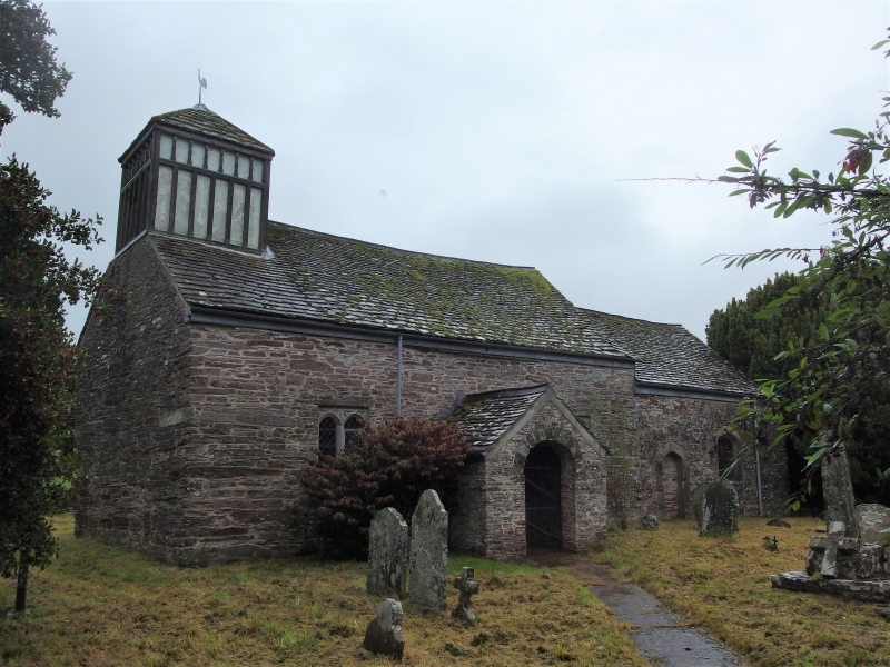
The original dedication to Welsh Saint Ciwa, implies pre-Norman origins. Following the initial Norman conquest of the Welsh kingdom of Gwent by William Fitz Osbern (Lord of Breteuil in Calvados), the Church at Llangua was given to the Benedictine Monastery at Lire in Normandy who established a monastic cell at Llangua. Nothing remains of the monastery, which survived until the Dissolution, and was said to have stood near the Great House, Llangua. The present church dates from the late medieval period. Nave roof and perp. windows are late C15. The chancel was built separately and may be earlier, although the E window is again late C15. The Victorian restoration of 1889 by Thomas Nicholson of Hereford added new windows and a vestry on the N side. In 1954-5 E A Roiser carried out major repairs for Ivor Bulmer-Thomas, former chairman of the Redundant Churches Fund, who restored the church as a memorial to his wife, Dilys Thomas.
Small late-C15 church with timber belfry. Rubble stone, some ashlar dressings, stone tile roof and tile ridge. Nave, chancel, vestry, porch, and timber bell-turret to W. Bell-turret is square with hipped roof; each wall face has lower panel of tall studs and above a row of small turned balusters. SE front has gabled entrance porch with semicircular arched doorway of stone voussoirs. To left, Nave S wall has late C15 Perp 2-light window with ribbed panelling above. To right of porch, is similar 3-light window. Straight joint in masonry between chancel and nave. Chancel S wall has a blocked Tudor arched doorway and Tudor arched window. NW elevation shows signs of Victorian restoration. Chancel, N wall has attached C19 vestry with pointed arched doorway and boarded door with ornamental strap hinges, and small lancet window. Nave N wall has off-centre C19 buttress with raking offsets, with (to right) C19 single-light window with four-centred arch, and (to left) similar 3-light window. E window is late C15 3-light window; lattice glazed.
Nave and chancel have stripped walls. Nave and chancel wagon roofs have moulded ribs, painted octagonal bosses and battlemented wall plate, all late C15. Deeply splayed window openings. Two rectangular aumbries on N and E walls of chancel. C18 panelled pulpit and reading desk. Carved wooden figure of St James on nave S wall. C19 six-light chandelier. Several fittings date from the 1955 restoration including altar rail, pews and font cover. At W end, post and panel partition has painted figures in four panels (Virgin and Child, Christ, a King (possibly St Edward) and an unidentified Bishop) and is said to have been imported 1954-5 from redundant chapel at Whitford, Devon.
Well-preserved and well-restored late C15 church with important surviving medieval fabric and good C18 pulpit and reading desk.
External links are from the relevant listing authority and, where applicable, Wikidata. Wikidata IDs may be related buildings as well as this specific building. If you want to add or update a link, you will need to do so by editing the Wikidata entry.


Other nearby listed buildings
