History in Structure

Cross in St Michael's Churchyard

A Grade II Listed Building in Mitchel Troy, Monmouthshire

More Photos »
Approximate Location Map
Large Map »

Coordinates

Latitude: 51.7898 / 51°47'23"N

Longitude: -2.7375 / 2°44'14"W

OS Eastings: 349230

OS Northings: 210384

OS Grid: SO492103

Mapcode National: GBR FK.YFKT

Mapcode Global: VH870.H8NS

Plus Code: 9C3VQ7Q7+W2

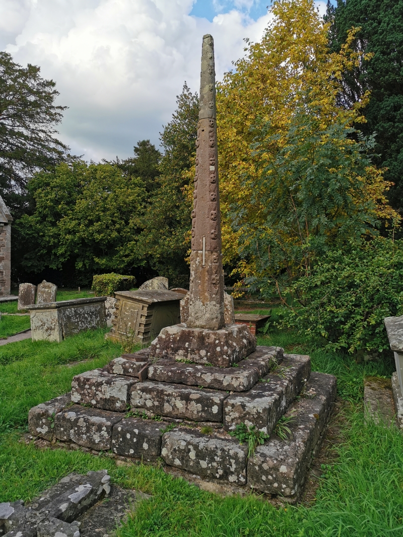
Entry Name: Cross in St Michael's Churchyard

Listing Date: 19 November 1953

Last Amended: 27 September 2001

Grade: II

Source: Cadw

Source ID: 2087

Building Class: Religious, Ritual and Funerary

ID on this website: 300002087

Location: In the centre of Mitchel Troy village, on the N side of the old road from Monmouth to Raglan

County: Monmouthshire

Town: Monmouth

Community: Mitchel Troy (Llanfihangel Troddi)

Community: Mitchel Troy

Traditional County: Monmouthshire

Tagged with: Churchyard cross

Find accommodation in
Mitchel Troy

Exterior

Restored medieval cross-shaft. Red sandstone. Mounted on a square plinth of 3 steps and set in a low cavetto-moulded base, it is about 3m high and rectangular in section, tapering from 37x32cm at the foot, and has convex corners decorated with small shields alternating with ball-flowers so crudely-carved as to resemble little. skulls.

Reasons for Listing

Included as a unusual example of a medieval preaching cross, and for its group relationship with the church.

External Links

External links are from the relevant listing authority and, where applicable, Wikidata. Wikidata IDs may be related buildings as well as this specific building. If you want to add or update a link, you will need to do so by editing the Wikidata entry.

Recommended Books

Other nearby listed buildings

  • II* Church of St Michael
    In the centre of Mitchel Troy village, on the N side of the old road from Monmouth to Raglan.
  • II Lychgate to Church of St Michael
    In the centre of Mitchel Troy village.
  • II Church Farmhouse
    In the centre of the village, about 150m SW of the church of St Michael, set back on the S side of the old road between Monmouth and Raglan, in the E angle of the minor road running S to Mitchel Troy
  • II Church Farmhouse, Barn to W
    About 150m SW of the church of St Michael and 10m W of Church Farmhouse, set back on the S side of the old road between Monmouth and Raglan, in the E angle of the minor road running S to Mitchel Troy
  • II* Church of St Wonnow
    About 2.5km SW of Monmouth, close to Wonastow Court on the S side of the minor road between Monmouth and Dingestow. Screened from the road by trees, but a conspicuous and attractive feature of the vi
  • II Cross in St Wonnow's churchyard
    About 20m N of the church of St Wonnow
  • II Wonastow Court
    Set in its own grounds on the S side of the road from Monmouth to Dingestow, about 2.5km SW of Monmouth. Standing in delightfully intimate proximity about 50m to the S is the Church of St Wonnow (q.v.
  • II Wonastow Lodge
    On the S side of a former drive to Wonastow Court, off the S side of the minor road from Monmouth to Wonastow; about 450m NE of Wonastow Court

BritishListedBuildings.co.uk is an independent online resource and is not associated with any government department. All government data published here is used under licence. Please do not contact BritishListedBuildings.co.uk for any queries related to any individual listed building, planning permission related to listed buildings or the listing process itself.

British Listed Buildings is a Good Stuff website.