Approximate Location Map
Large Map »
Latitude: 53.1855 / 53°11'7"N
Longitude: -4.4922 / 4°29'31"W
OS Eastings: 233574
OS Northings: 368277
OS Grid: SH335682
Mapcode National: GBR 57.378D
Mapcode Global: WH433.Z618
Plus Code: 9C5Q5GP5+54
Entry Name: Retaining Wall for Church of St. Cwyfan
Listing Date: 25 November 1998
Last Amended: 25 November 1998
Grade: II
Source: Cadw
Source ID: 20965
Building Class: Religious, Ritual and Funerary
ID on this website: 300020965
County: Isle of Anglesey
Community: Aberffraw
Community: Aberffraw
Locality: Porth Cwyfan
Traditional County: Anglesey
Tagged with: Wall
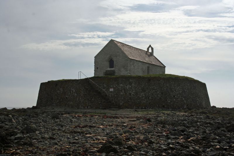
The retaining wall contains the probably built-up small island on which the church is situated, but has no readily dateable features. It is likely that it is late medieval in origin, though there is evidence of extensive subsequent repair.
Retaining wall to island. Rough rubble walls, battered and angled to enclose the irregularly shaped small island. Stone steps incorporated within curved inset on the landward side, with simple iron rail.
The wall serves to enclose the entire small island and is therefore a highly significant landscape feature and a very important part of the setting of the church.
External links are from the relevant listing authority and, where applicable, Wikidata. Wikidata IDs may be related buildings as well as this specific building. If you want to add or update a link, you will need to do so by editing the Wikidata entry.


Other nearby listed buildings
