Approximate Location Map
Large Map »
Latitude: 53.1935 / 53°11'36"N
Longitude: -3.5631 / 3°33'47"W
OS Eastings: 295667
OS Northings: 367405
OS Grid: SH956674
Mapcode National: GBR 6F.2YSS
Mapcode Global: WH65N.7ZKP
Plus Code: 9C5R5CVP+9Q
Entry Name: Pont Rhydyrarian
Listing Date: 30 January 1968
Last Amended: 21 July 1999
Grade: II
Source: Cadw
Source ID: 214
Building Class: Transport
ID on this website: 300000214
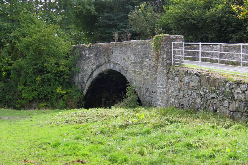
Location: Road bridge carrying the B5382, and spanning the Afon Deunant, at the centre of the hamlet of Bryn Rhydyrarian.
County: Conwy
Community: Llansannan
Community: Llansannan
Locality: Bryn Rhydyrarian
Traditional County: Denbighshire
Tagged with: Bridge Road bridge
Built in 1797, at a cost of £130; by David Lewis, stone mason, and John Jones, joiner. The stone was to be quarried from the land of Philip Yorke Esq, or from the quarry on the land of the Glanywirn Family.
Roadbridge, built of local rubble masonry; a single wide segmental span over the river, the stonework of the arch slightly recessed from main wall of the bridge. The walls of the parapets stand to a height of c.1m above the road level, and have plain copings.
Included as a good example of a late C18 roadbridge.
External links are from the relevant listing authority and, where applicable, Wikidata. Wikidata IDs may be related buildings as well as this specific building. If you want to add or update a link, you will need to do so by editing the Wikidata entry.


Other nearby listed buildings
