Approximate Location Map
Large Map »
Latitude: 51.8123 / 51°48'44"N
Longitude: -2.7169 / 2°43'0"W
OS Eastings: 350675
OS Northings: 212872
OS Grid: SO506128
Mapcode National: GBR FL.X0NX
Mapcode Global: VH86T.VQK1
Plus Code: 9C3VR76M+W6
Entry Name: Monmouth Castle
Listing Date: 15 August 1974
Last Amended: 10 August 2005
Grade: I
Source: Cadw
Source ID: 2216
Building Class: Defence
Also known as: Castell Trefynwy
ID on this website: 300002216
Location: The Castle is situated on a commanding site on the east bank of the river Monnow at the highest point of the town and just north of the town square.
County: Monmouthshire
Town: Monmouth
Community: Monmouth (Trefynwy)
Community: Monmouth
Built-Up Area: Monmouth
Traditional County: Monmouthshire
Tagged with: Castle Destroyed building or structure
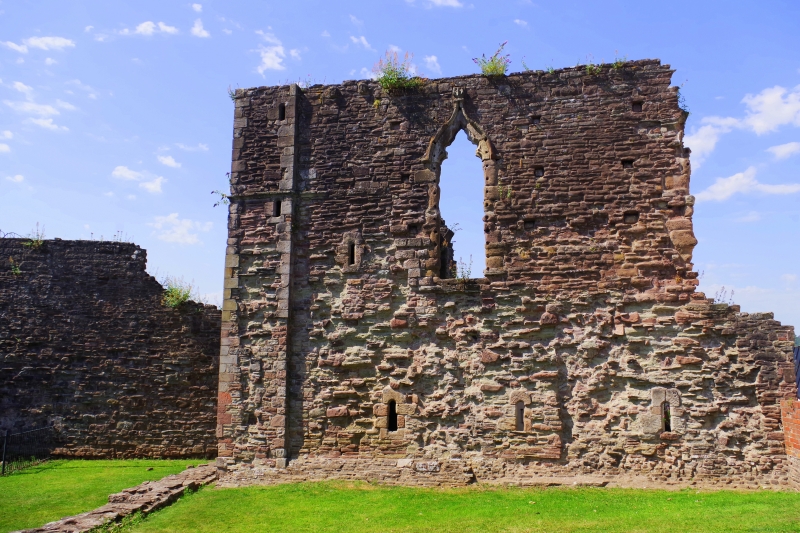
Substantial portions remain of the C11-12 Norman castle. This was developed during the C13-14 to form the nucleus of an elaborate defensive system in the centre of Monmouth, together with the town walls and ditches and other surviving features such as the Dixton Gate (now incorporated in The Nag's Head Inn (qv), Monnow Bridge (qv) and Clawdd du Bridge (qv). The Castle was extended and improved by John of Gaunt in the mid C14 and was the birthplace in 1387 of Harry of Monmouth, later Henry V. The Castle was involved in the Civil War on the Royalist side after which it rapidly became ruinous. The great Round Tower, illustrated by Speed, was demolished in 1647 to make way for Great Castle House (qv), which was constructed in 1673 using the recovered stone. The Great Hall continued in use as a courtroom until 1724 which probably ensured the survival of at least part of the structure. Today significant remains exist only of the Keep or Great Tower which was much altered in C14, probably c1360 and of the Great Hall which was added in mid C13, possibly 1270. The Castle was in the ownership of the Worcester and Beaufort families until the C20 when it became vested in the Ministry of Works.
Built largely of purple and red local sandstone rubble with quoins and repairs in dressed sandstone, and patching, much of this is C20, to the projecting corners of the Great Tower. The surviving walling is more considerable than at first appears. The Great Tower is a large rectangular one with wide faces and three clasping buttressed corners. The walling between is largely missing on the north (river) side and at the south-east corner; slighted following the Civil War and then robbed afterwards to build Great Castle House in 1673. The architectural character of the openings changes in the upper walling as does the stone type indicating a major strengthening and general improvement in the late C14. One opening at this level has a cusped ogee head while the doorway into the Great Hall has a head with a triple mould. The adjoining Great Hall is more ruinous despite having stayed in use as a courtroom until 1724. The north and west walls survive, the taller having two large windows.
Interior only partly inspected at resurvey.
Included and highly graded despite its ruined state as the key historic building in the development of the town of Monmouth.
Scheduled Ancient Monument: MM159(MON).
External links are from the relevant listing authority and, where applicable, Wikidata. Wikidata IDs may be related buildings as well as this specific building. If you want to add or update a link, you will need to do so by editing the Wikidata entry.


Other nearby listed buildings
