Approximate Location Map
Large Map »
Latitude: 52.7513 / 52°45'4"N
Longitude: -3.695 / 3°41'42"W
OS Eastings: 285692
OS Northings: 318421
OS Grid: SH856184
Mapcode National: GBR 68.ZNX9
Mapcode Global: WH67X.63QM
Plus Code: 9C4RQ823+GX
Entry Name: Ty'n y Twll
Listing Date: 4 November 1999
Last Amended: 4 November 1999
Grade: II
Source: Cadw
Source ID: 22577
Building Class: Domestic
ID on this website: 300022577
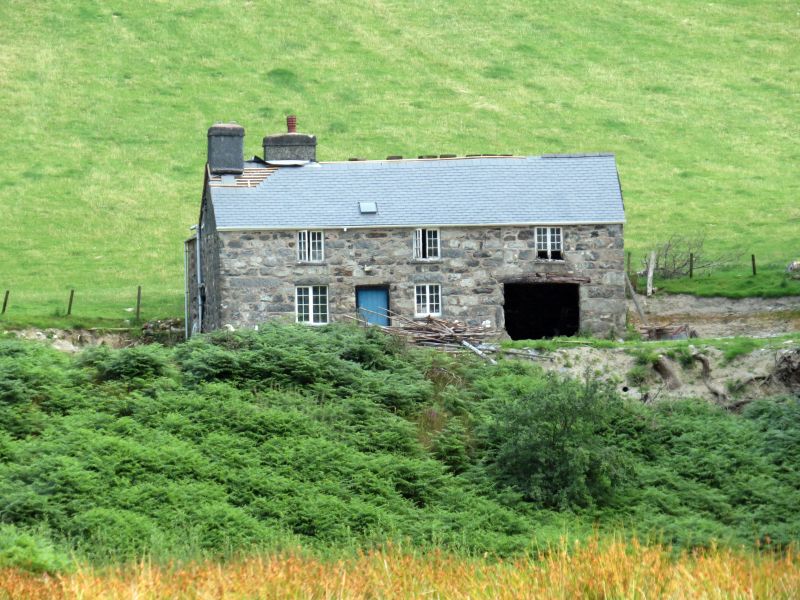
Location: The house stands in a slightly elevated position near the head of the Cwm Cywarch, facing over to the W.
County: Gwynedd
Town: Machynlleth
Community: Mawddwy
Community: Mawddwy
Locality: Dinas Mawddwy
Traditional County: Merionethshire
Tagged with: Farmhouse
Built in the early-mid C19 as a more substantial farmhouse of this upland area.
Built of coursed rubble, slate roof with rooflight and large gable stack at the N end. Two storeys, symmetrical 2-bay frontage extending to the right as an open fronted cart shed. Central boarded door in a frame set back in the thickness of the wall. Two light small-paned windows to either side of the door and on the upper floor, with a further one over the entrance door. The cartshed to the right has a cambered timber lintel, and a granary over, accessed by an external stone stair at the gable end. On the left, a 2-storey 1 bay rear service wing, apparently contemporary, with a door and 2-light windows to each floor and a gable stack.
Living room on the left, a central stair hall, and the parlour, originally unheated, on the right.
Included as a typical and well preserved example of a more substantial upland farmhouse, reflecting the increasing prosperity of farming in remote valley bottom areas of the time.
External links are from the relevant listing authority and, where applicable, Wikidata. Wikidata IDs may be related buildings as well as this specific building. If you want to add or update a link, you will need to do so by editing the Wikidata entry.


Other nearby listed buildings
