History in Structure

Kingsley House

A Grade II Listed Building in Monmouth, Monmouthshire

More Photos »
Approximate Location Map
Large Map »

Coordinates

Latitude: 51.8143 / 51°48'51"N

Longitude: -2.7132 / 2°42'47"W

OS Eastings: 350928

OS Northings: 213088

OS Grid: SO509130

Mapcode National: GBR FL.WTWR

Mapcode Global: VH86T.XNHK

Plus Code: 9C3VR77P+PP

Entry Name: Kingsley House

Listing Date: 27 October 1965

Last Amended: 10 August 2005

Grade: II

Source: Cadw

Source ID: 2275

Building Class: Domestic

ID on this website: 300002275

Location: On the principal road which runs north-south on the east side of Monmouth town centre.

County: Monmouthshire

Town: Monmouth

Community: Monmouth (Trefynwy)

Community: Monmouth

Built-Up Area: Monmouth

Traditional County: Monmouthshire

Tagged with: House

Find accommodation in
Monmouth

History

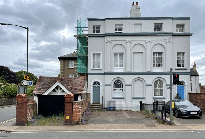
1839 semi-detached reflected pair designed by G V Maddox. When built Kingsley House was the home of G V Maddox, the Monmouth architect, who also probably designed the houses. It has been suggested that the facade may have been added to an older house, but no evidence is visible for this.

Interior

Interior not seen at resurvey.

Reasons for Listing

Included for its special architectural interest as a fine pair of neo-classical semi-detached houses by the leading Monmouth architect.

External Links

External links are from the relevant listing authority and, where applicable, Wikidata. Wikidata IDs may be related buildings as well as this specific building. If you want to add or update a link, you will need to do so by editing the Wikidata entry.

Recommended Books

Other nearby listed buildings

  • II Hendre House
    On the principal road which runs north-south on the east side of Monmouth town centre.
  • II Victoria Place
    On corner site at junction with Monk Street. Part of the group on the principal street leading north and east from the town square.
  • II Victoria Place
    Part of the group on the principal street leading north and east from the town square.
  • II NO.12 Monk Street, Gwent
    On the principal road which runs north-south on the east side of Monmouth town centre.
  • II* The Masonic Temple, including Tyler's Residence
    On the principal road which runs north-south on the east side of Monmouth town centre.
  • II NO.14 Monk Street, Gwent
    On the principal road which runs north-south on the east side of Monmouth town centre.
  • II NOS.16 & 18 Monk Street, Gwent
    On the principal road which runs north-south on the east side of Monmouth town centre.
  • II Ty-mawr
    On the principal road which runs north-south on the east side of Monmouth town centre at the junction with Dixton Road.

BritishListedBuildings.co.uk is an independent online resource and is not associated with any government department. All government data published here is used under licence. Please do not contact BritishListedBuildings.co.uk for any queries related to any individual listed building, planning permission related to listed buildings or the listing process itself.

British Listed Buildings is a Good Stuff website.