Approximate Location Map
Large Map »
Latitude: 51.6525 / 51°39'9"N
Longitude: -4.251 / 4°15'3"W
OS Eastings: 244374
OS Northings: 197261
OS Grid: SS443972
Mapcode National: GBR GQ.YW72
Mapcode Global: VH3MH.8QJJ
Plus Code: 9C3QMP3X+2H
Entry Name: Whiteford Lighthouse
Listing Date: 3 March 2000
Last Amended: 3 March 2000
Grade: II*
Source: Cadw
Source ID: 22885
Building Class: Civil
Also known as: Whiteford Point Lighthouse
Iron Lighthouse at Whitford Point
ID on this website: 300022885
Location: On a shingle bank to the south of the entrance to Burry River, and to the north of Whiteford Sands, 4 km north of Llanmadoc village
County: Swansea
Town: Swansea
Community: Llangennith, Llanmadoc and Cheriton (Llangynydd, Llanmadog a Cheriton)
Community: Llangennith, Llanmadoc and Cheriton
Locality: Whiteford
Built-Up Area: Burry Port
Tagged with: Lighthouse
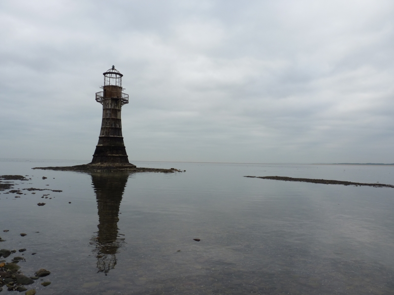
Built in 1865 by the Llanelli Harbour and Burry Navigation Commissioners to replace an earlier structure; the lighthouse remained in use until 1921. The name of the designer is not recorded. It follows a C19 tradition of cast iron lighthouses, cast iron having first been used in the construction of a lighthouse at Maryport, Cumbria, in 1834. Whiteford is thought to be the only remaining major cast-iron lighthouse in the British Isles, and is an important monument of C19 engineering construction.
Whitford marks the south side of the navigable channel to Llanelli. Following disuse the lighthouse was leased by the Llanelli Harbout Trust to the Nature Conservancy Council.
Built of cast iron plates externally flanged and bolted, in seven rings rising to the main gallery. The form tapers, from about 6½ metres diameter at base to about 3½ metres diameter at the top.The external positioning of the flanges is an unusual and arguably impractical detail, the reason for which is unexplained. Above this there is a gallery, a final ring of cast-iron plates, a top gallery, and the lantern; altogether over 15 metres high. At high tide the lighthouse stands in 6 metres of water. Wrought iron bands have been added to strengthen the structure near base level.
The main gallery consists of iron balusters linked at top by trefoils, carried on bellied iron beams. Access to the gallery and thence to the interior was by an external ladder (now mostly missing). The lantern is designed as three rows of sixteen rectangular panes. Copper glazing bars. The lantern roof was originally also in copper.
The lowest part of the structure is believed to be stone-filled. There appear to have been two rooms at the top for lighthousemen.
Listed at II* as a rare survival of a wave-swept cast-iron lighthouse in British coastal waters, and an important work of C19 lighthouse design and construction.
Scheduled Ancient Monument GM407 (SWA).
External links are from the relevant listing authority and, where applicable, Wikidata. Wikidata IDs may be related buildings as well as this specific building. If you want to add or update a link, you will need to do so by editing the Wikidata entry.


