Approximate Location Map
Large Map »
Latitude: 51.7987 / 51°47'55"N
Longitude: -2.7147 / 2°42'53"W
OS Eastings: 350808
OS Northings: 211354
OS Grid: SO508113
Mapcode National: GBR FL.XTFG
Mapcode Global: VH870.W1PZ
Plus Code: 9C3VQ7XP+F4
Entry Name: Walled Garden to W of Troy House
Listing Date: 29 March 1993
Last Amended: 27 September 2001
Grade: II*
Source: Cadw
Source ID: 2886
Building Class: Domestic
ID on this website: 300002886
Location: On sloping ground about 50m W of Troy House on the S bank of the River Trothy, on the W side of a farm track running S from a bend in the road about 1.5km S of Monmouth.
County: Monmouthshire
Town: Monmouth
Community: Mitchel Troy (Llanfihangel Troddi)
Community: Monmouth
Locality: Mitchel Troy
Traditional County: Monmouthshire
Tagged with: Walled garden
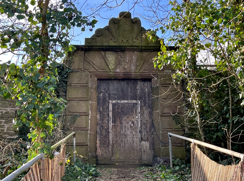
Early C17 walled garden, predating the present Troy House which was built c1660-70. The main entrance is recorded as having been inscribed with the date 1611; the surviving initials ECS refer to Elizabeth and Charles Somerset, the latter was the son of Henry, 1st Marquis of Worcester (of Raglan Castle), and 1611 was the date of their marriage. This garden is also noted for having caught the interest of Charles I who, when staying at Raglan Castle in 1645, was presented with a gift of its exotic fruits - he remarked that "he had heard the corn now grew where Troy town stood, but never before apricots!". It is now largely pasture, retaining only a few fruit trees; the W end is now a nun's graveyard and on the S side modern houses have been built.
Large rectangular garden bordered by high stone walls constructed of local sandstone rubble with dressed stone quoins.
The principal feature is the main entrance reached up steps at the middle of the E side. This is a fine and ambitious example of early C17 Classical design, some elements of which recall the work of the Smythsons, in particular the style of John Smythson - see his slightly later work at Bolsover. It is composed of an ashlar, rusticated doorway with fluted jambs and ogee stops; above the cornice is an initialled shield in a strapwork and ornamented surround; boarded and studded door opening onto a stone barrel vaulted lobby. The side facing into the garden has a semi-circular archway which has greater emphasis to the rustication and distinctive ovals to the imposts and keystone. The roof of this entrance has been replaced with asbestos tiles. Other notable features to the garden are two recesses that are probably bee-boles; both have Tudor hoodmoulds and central shelves, one to E side beside the main entrance and the other on N side. Otherwise the N side is approximately 4m high at its E end and has flat coping and is slightly battered. The W side is lower and has blocked central entrance. S side is altered by erection of modern houses which towards its E end creates a break in the wall. The wall is complete to E side (approximately 3.5m high) with two buttresses to N end. A small enclosure to W end is used as a nun's graveyard and in the centre of the garden are the remains of a red brick building. A conservatory formerly existed to SE corner. The C17 layout is thought to be preserved beneath the turf.
Group value with Troy House.
Graded II* as an exceptional example of a well documented early C17 walled garden with some especially fine detail and notable historical associations.
External links are from the relevant listing authority and, where applicable, Wikidata. Wikidata IDs may be related buildings as well as this specific building. If you want to add or update a link, you will need to do so by editing the Wikidata entry.


Other nearby listed buildings
