Approximate Location Map
Large Map »
Latitude: 53.2289 / 53°13'43"N
Longitude: -3.8419 / 3°50'30"W
OS Eastings: 277141
OS Northings: 371788
OS Grid: SH771717
Mapcode National: GBR 62.0P6L
Mapcode Global: WH54C.Y3PH
Plus Code: 9C5R65H5+H6
Entry Name: Tyddyn-y-Pwll
Listing Date: 17 March 1953
Last Amended: 21 February 1996
Grade: II
Source: Cadw
Source ID: 3156
Building Class: Domestic
ID on this website: 300003156
Location: Located to the S of Roewen Road at the W extremity of the village; accessed via a farm track which passes the building on the R and continues to terminate at Bryn Derw farm.
County: Conwy
Community: Caerhun
Community: Caerhun
Locality: Ty'n-y-Groes
Traditional County: Caernarfonshire
Tagged with: Farmhouse
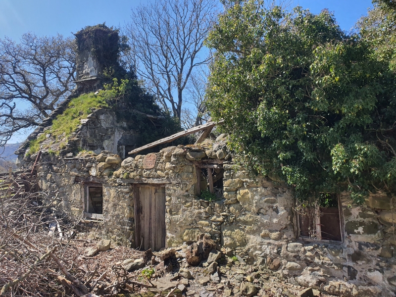
Also known as Tyddyn Honda. Mentioned in 1607 though the present house is a rebuild of 1703 for Rowland Jones, who died in 1740 aged 83.
One-and-a-half storey 3-bay farmhouse, of whitened rubble construction with boulder foundations. Old slate roof, the northern half of which had collapsed at the time of inspection (November 1995); plain end chimneys. Near-centre entrance with pegged oak doorcase and boarded door. Above the entrance, a stone plaque inscribed: 'RI ME/ TANGHEFEDD/ DDVW A FO YN/ YN TV HWN/ AMEN 1703.' Flanking the entrance are 2-light unglazed windows with timber lintels. Three 2-light casement windows to the attic floor, contained within plain gabled dormers. 2 plain, unglazed window openings to the rear.
The interior was not inspected at the time of survey (November 1995), though an original 4-bay collar truss roof and dividing boarded partitions are recorded.
Listed despite its condition as a largely unaltered and dated example of a vernacular early C18 farmhouse.
External links are from the relevant listing authority and, where applicable, Wikidata. Wikidata IDs may be related buildings as well as this specific building. If you want to add or update a link, you will need to do so by editing the Wikidata entry.


Other nearby listed buildings
