Approximate Location Map
Large Map »
Latitude: 53.1228 / 53°7'21"N
Longitude: -4.3322 / 4°19'55"W
OS Eastings: 244036
OS Northings: 360941
OS Grid: SH440609
Mapcode National: GBR 5F.7B3S
Mapcode Global: WH43D.FR9W
Plus Code: 9C5Q4MF9+44
Entry Name: Fort Belan
Listing Date: 29 May 1968
Last Amended: 30 September 1999
Grade: I
Source: Cadw
Source ID: 3810
Building Class: Defence
Also known as: Caer Belan
ID on this website: 300003810
Location: Situated 4km south-west of Caernarfon reached along a track to the head of the short peninsula north of Dinas and Morfa Dinlle with dock immediately to east.
County: Gwynedd
Town: Caernarfon
Community: Llandwrog
Community: Llandwrog
Locality: Morfa Dinlle
Traditional County: Caernarfonshire
Tagged with: Fort
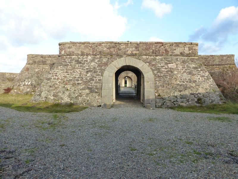
Fort Belan (originally known as Fort David) was begun in 1775 by Thomas Wynn as a coastal battery for his Caernarvonshire Militia; this was previously garrisoned at the smaller Fort Williamsburg which he had built in 1761 at his family home, Glynllifon. The building of this earlier fort followed Wynn's election as MP for Caernarvonshire and his appointment as Lord Lieutenant which made him responsible for the Miltia. It was the American War of Independence that created the background to Wynn's decision to build Fort Belan; he garrisoned it at his own expense and it is the only British purpose-built defence relating to this war. Following the French invasion of Wales in 1797 the vulnerability of Britain's coast led to Wynn, now Lord Newborough, garrisoning Belan with the 'Loyal Newborough Volunteers' which were regarded as one of the best equipped regiments in the country. In 1824-6 the fort was extended and given additional guns and the adjoining dock was built. Fort Belan is now holiday accommodation.
Compact coastal fortification based upon the polygonal system with a curtain-wall and concentric walls enclosing a stone-reveted ditch and inner parade and barracks; the design may have been influenced by the grander, government-built Fort George on the Moray Firth, Scotland which was begun in the mid C18. Fort Belan is oblong in plan with salients to the north and south ends and is constructed of rubblestone with slate roofs to the inner ranges. At the landward end the wall projects in the form of a redan containing a gun platform with broadly battered walls and rounded corners; an inner wall runs from this towards the circular sentry towers to west and east and then north as a further defence to the inner barracks. The main entrance is through a vaulted tunnel under the gun platform and across the ditch via a drawbridge; the tunnel has ashlar surrounds to the round-arched gateways at either end. This leads to the crenellated perimeter wall (part cement-rendered to south and buttressed to sides) of the inner parade and its gatehouse with mock cross-loops and broad archways flanked by rectangular gun-ports; over the arch is a plaque of a double-headed eagle, the Wynn family emblem. Outbuildings at this end include stables to east with brick voussoirs and possible magazine to west. The barrack quarters (partly later) to the west and east sides of the grassed parade are cement rendered with mostly monopitch slate roofs, cement-rendered chimneys and various small-pane sash windows and porches with segmental arched entrances. Belan House and Newborough House to the west have camber-headed windows; Newborough House has subsequently been enlarged with gable to right of porch and square-headed sashes; the 4-window range at the far north end is stepped forward. On the east side the 5-bay central block named Over The Way is stepped up with central porch flanked by camber-headed 16-pane sashes. At the north end is a further gatehouse flanked on the inner side by monopitch powder stores; sundial over the archway is dated 1898 and the timber navigation look-out tower on top is a later addition. At the extreme north end is a gun battery platform which retains 14 cannon dated 1846 or 1847 and one smaller cannon to centre; both this and the wall-walk are reached by steps (eg beyond north end inner gatehouse) and ramps at north-west and north-east corners. On either side, sunk between the inner wall-walk and parade buildings at the centre are half-hipped roof buildings; that to east is of rubblestone with broad carriage arch and half-glazed doors and that to the west is weatherboarded. At the north-west end is the former bakehouse and at the north end of the east side is a postern gate which enters underneath the inner wall-walk.
Interior not accessible at time of Survey.
Listed Grade I as an exceptionally complete example of a late C18 coastal fortification which is most unusual in having being privately built and unique in being the only purpose-built British defence relating to the American War of Independence; this combination places Fort Belan in a very important position in national military history.
External links are from the relevant listing authority and, where applicable, Wikidata. Wikidata IDs may be related buildings as well as this specific building. If you want to add or update a link, you will need to do so by editing the Wikidata entry.


Other nearby listed buildings
