Approximate Location Map
Large Map »
Latitude: 52.9521 / 52°57'7"N
Longitude: -4.4898 / 4°29'23"W
OS Eastings: 232833
OS Northings: 342320
OS Grid: SH328423
Mapcode National: GBR 57.L1TJ
Mapcode Global: WH449.0294
Plus Code: 9C4QXG26+V4
Entry Name: Church of St Beuno
Listing Date: 19 October 1971
Last Amended: 18 May 1999
Grade: I
Source: Cadw
Source ID: 4374
Building Class: Religious, Ritual and Funerary
ID on this website: 300004374
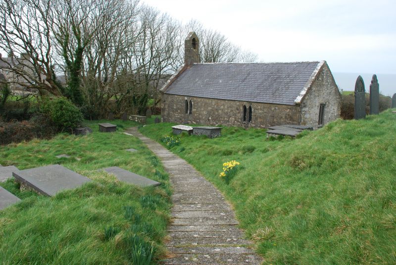
Location: The church is set on a sloping site in a narrow valley below the later hamlet of Pistyll, and below the former road line of the Llithfaen to Nefyn road.
County: Gwynedd
Town: Pwllheli
Community: Pistyll
Community: Pistyll
Traditional County: Caernarfonshire
Tagged with: Church building
Pistyll, a vill of Llannor, was a station on the early pilgrimage route from Clynnog to Bardsey, one particularly associated with St Beuno, the early C7 abbot and saint whose main missionary centre was at Clynnog-fawr. The present church is possibly of C12 origin, extended later to the E and re-roofed in the C15. The W end wall has also been partially rebuilt, probably in the C15 when the W door was inserted, and when the W end roof truss was removed. The ancient tradition of decorating the church with flowers and spreading the floor with sweet smelling herbs is still maintained every Christmas, Easter and August.
Built of rhyolite rubble on large exposed boulder foundations and megalithic quoins, with a slate roof replacing thatch between raised and coped gables. Some external rendering survives on the E and S sides. The church is a single cell structure with a tall and simple gabled bellcote at the lower, W end, and added buttresses either side of the W door, itself replacing a blocked door at the W end of the S side. Two windows of paired lancets in unmoulded jambs, with a flush round arch of rubble over, on the S side, and one small single-splayed lancet window on the N lighting the presbytery. The wooden 2-light E window is of recent origin, and the NW corner appears rebuilt.
The simple interior is of 5 roof bays, divided by five C15 arch-braced roof trusses supporting two tiers of purlins and a ridge, the fifth truss being against the E wall. The arch braces are chamfered. The upper part of the walls is boarded and has a stilted inner wall plate to the centre bays. At the E end, the small high-set window on the N side has reveals for a corresponding window on the S side. Two steps lead up to the altar, which has a C19 oak communion rail. The walls are unplastered, but an indistinct wall painting of St Christopher survives on a remaining area of plaster on the N side. Limed oak pews, pulpit and readers desk, and at the SW corner by the door, a boarded parclose screen. The important C11 cylindrical font is slightly tapered, and is set on a later pedestal and base. It is carved with a continuous bold Anglo-Scandinavian 2-strand chain interlace design around the exterior of the bowl. Fragmentary black-lettered inscription in Welsh noted on E wall by RCAHM.
Included at Grade I as a fine and largely unaltered example of the smaller medieval church of west Wales, including a medieval wall painting and an important early carved font.
External links are from the relevant listing authority and, where applicable, Wikidata. Wikidata IDs may be related buildings as well as this specific building. If you want to add or update a link, you will need to do so by editing the Wikidata entry.


Other nearby listed buildings
