History in Structure

Caergeiliog Tollhouse

A Grade II Listed Building in Caergeiliog, Isle of Anglesey

More Photos »
Approximate Location Map
Large Map »

Coordinates

Latitude: 53.2771 / 53°16'37"N

Longitude: -4.5439 / 4°32'37"W

OS Eastings: 230482

OS Northings: 378584

OS Grid: SH304785

Mapcode National: GBR HN41.CCK

Mapcode Global: WH42J.5WJL

Plus Code: 9C5Q7FG4+RF

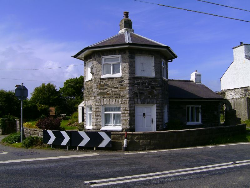
Entry Name: Caergeiliog Tollhouse

Listing Date: 1 August 1952

Last Amended: 7 September 1998

Grade: II

Source: Cadw

Source ID: 5266

Building Class: Transport

ID on this website: 300005266

Location: Located on the S side of the A5(T) Holyhead Road, at the junction with the road leading to Llanfair-yn-neubwll, at the NW end of the village of Caergeiliog.

County: Isle of Anglesey

Community: Llanfair-yn-Neubwll

Community: Llanfair-yn-Neubwll

Locality: Caergeiliog

Built-Up Area: Caergeiliog

Traditional County: Anglesey

Tagged with: Tollhouse

Find accommodation in
Valley

History

Following the Act of Union in 1801 a programme to improve the roads between the two capital cities of London and Dublin was initiated. In 1811 Thomas Telford was commissioned to undertake a survey of the roads between London and Holyhead and in 1817 began work on the northern stretch of the road at Shrewsbury. Work started on Anglesey in 1818 and 5 tollhouses, designed by Telford, were built across the island. In 1844 a law was passed abolishing tolls from Holyhead to Shrewsbury but an exemption was made of the tollhouses of Anglesey where charges were actually increased and proved adequate for the maintenance of the roads for several years. In 1895 the exemption ended and on 28th November the tollhouses were sold.

Exterior

Octagonal 2-storey toll house forming a symmetrical composition with single storey wings to W and S. Walls of rubble, coursed between the openings in the octagon and with voussoir lintels. Slate roof with projecting eaves. Central stack to octagon with gable stacks to each wing. Windows are slightly recessed with modern casements; upper storey of octagonal with blind recesses in N and E face.

Reasons for Listing

Listed as one of a series of tollhouses designed for the Holyhead Road by Thomas Telford, retaining its original form (notwithstanding alterations to detail).

External Links

External links are from the relevant listing authority and, where applicable, Wikidata. Wikidata IDs may be related buildings as well as this specific building. If you want to add or update a link, you will need to do so by editing the Wikidata entry.

Recommended Books

Other nearby listed buildings

  • II Telford Milestone
    Located on the N side of the A5(T), Holyhead Road. NW of Caergeiliog Tollhouse, at the NW end of the village of Caergeiliog.
  • II Siloh Baptist Chapel and Chapel House with walls, railings and gates
    Located in the centre of the village of Caergeiliog, set back from the S side of the A5(T) Holyhead Road. The chapel and chapel house are set within enclosed grounds bounded by a low rubble wall with
  • II Pencaledog
    Located W of Caergeiliog, on the N side of the A5. Former farmstead with buildings in a parallel range, with the house being to the W. To the E is a 2-storey former bakehouse, built of similar mater
  • II Caergeiliog Chapel House with stables and cartshed
    Located in a slightly elevated position, set back slightly from the S side of the A5(T) Holyhead Road at the SW end of the village of Caergeiliog. Chapel house is at W side of walled yard to front of
  • II Caergeiliog Chapel
    Located in a slightly elevated position, set back slightly from the S side of the A5(T) Holyhead Road at the SW end of the village of Caergeiliog. Chapel house is at W side of walled yard to front of
  • II Church of St Mary
    Set within a sub-rectangular enclosed churchyard, in an isolated location reached by a narrow track leading to Ty'n-llan farm. Situated c1km SE of Pont Traeth Cleifiog and c1.5km SW of Caergeiliog.
  • II Tyddyn Du
    In an isolated location, set back from the road and reached by a private driveway, c350m ESE of the Church of St. Mary in Llanfair-yn-neubwll.
  • II Pont Traeth Cleifiog (partly in Valley Community)
    Located c0.5km S of Valley, spanning the estuary between Llanfair-yn-neubwll and Valley communities by road.

BritishListedBuildings.co.uk is an independent online resource and is not associated with any government department. All government data published here is used under licence. Please do not contact BritishListedBuildings.co.uk for any queries related to any individual listed building, planning permission related to listed buildings or the listing process itself.

British Listed Buildings is a Good Stuff website.