Approximate Location Map
Large Map »
Latitude: 53.2629 / 53°15'46"N
Longitude: -4.0929 / 4°5'34"W
OS Eastings: 260500
OS Northings: 376033
OS Grid: SH605760
Mapcode National: GBR JN82.FWS
Mapcode Global: WH542.378X
Plus Code: 9C5Q7W74+5R
Entry Name: Sailors' Return Public House
Listing Date: 20 February 1978
Last Amended: 13 July 2005
Grade: II
Source: Cadw
Source ID: 5632
Building Class: Commercial
Also known as: Sailors Return
The Sailors Return, Beaumaris
ID on this website: 300005632
Location: Fronting the street in a block of buildings between Rating Row and Wexham Street.
County: Isle of Anglesey
Town: Beaumaris
Community: Beaumaris (Biwmares)
Community: Beaumaris
Built-Up Area: Beaumaris
Traditional County: Anglesey
Tagged with: Pub
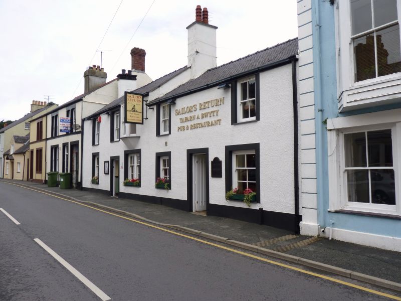
Built in the late C18 or early C19 and shown on the 1829 town plan and 1889 Ordnance Survey as a public house (No 40 to the R) and a house (No 42 to the L). No 42 was a draper's shop in 1910. They were later amalgamated into a single public house.
A public house amalgamating two 2-storey houses, of which the L-hand is higher, of whitened pebble-dashed walls with smooth-rendered architraves painted black, slate roofs and 3 roughcast stacks. On the 2-window R-hand side is a ribbed replacement door, 6-pane horned sash windows in the lower storey, larger to the R, and similar 4-pane windows in the upper storey. On the 3-window L-hand side the entrance is offset to the R of centre, and has a replacement ribbed door. It has paired 6-pane horned sashes to the R, a similar but larger single sash window to the L and, in the upper storey, 4-pane sashes to the centre and L, and an oriel window to the R with 2-pane sash.
The rear has a large 1-storey projection.
Modernised interior.
Listed for its special architectural interest as a public house formed from 2 small houses retaining definite C19 character, and for its contribution to the historical integrity of Church Street.
External links are from the relevant listing authority and, where applicable, Wikidata. Wikidata IDs may be related buildings as well as this specific building. If you want to add or update a link, you will need to do so by editing the Wikidata entry.


Other nearby listed buildings
