Approximate Location Map
Large Map »
Latitude: 53.2817 / 53°16'54"N
Longitude: -4.5635 / 4°33'48"W
OS Eastings: 229194
OS Northings: 379151
OS Grid: SH291791
Mapcode National: GBR HN30.VT8
Mapcode Global: WH42H.WS30
Plus Code: 9C5Q7CJP+MJ
Entry Name: Valley Railway Station Main Building
Listing Date: 30 July 1991
Last Amended: 19 January 1998
Grade: II
Source: Cadw
Source ID: 5759
Building Class: Transport
ID on this website: 300005759
Location: At the S end of Valley, on the 'up' platform immediately NW of the level crossing over the B4545.
County: Isle of Anglesey
Community: Valley (Y Fali)
Community: Valley
Built-Up Area: Valley
Traditional County: Anglesey
Tagged with: Railway station Station building
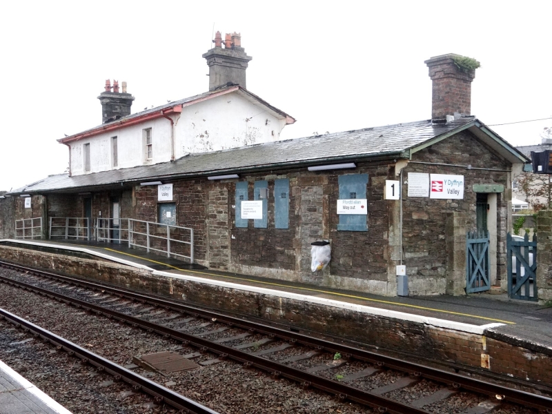
The Chester to Holyhead railway was proposed to improve links between London and Dublin. The parliamentary bill was passed in July 1844 with Robert Stephenson as engineer and Francis Thompson of Derby as architect. Valley, opened in October 1849, was one of the first stations on this line and, like Bodorgan, is a good example of Thompson's 'small' country station design. Valley and Bodorgan are the only two early stations to be stone-built. The goods shed was probably added in 1851, contemporary with Bodorgan; the station building was extended in 1870. Closed in 1966 but re-opened briefly in the 1980's, the station is now closed.
Two-storey, 3 window range main block, front with ground floor canopy, the roof of which continues over simple flanking single-storey, single bay wings, that to right extended by 2 bays. Ruled render to 1st floor and random rubble stone to ground floor with freestone dressings including architraves, sill band and quoins. Slate roof with boarded eaves and moulded timber kneelers; 2 large rendered stacks with cornices to main block, set in from gable ends; brick stack set in from gable end of right wing. Platform-facing front elevation of 3 bays, boarded up doorways to ground floor and windows to first floor; said, in previous listing description, to contain sash windows with glazing bars; marginal glazing bars to central window and paired central mullion to outer windows. Blocked window to front of left wing; right wing 1-3-1 boarded windows interspersed with 2 blocked doorways, boarded doorway to right gable return. Rubble rear; roof of main block continues down over projected centre with tall boarded window; lean-to's at either side, that to left with shorter boarded window. Smaller openings to rear of flanking wings now boarded.
Listed as a good and complete example of one of the earliest stations on this line.
External links are from the relevant listing authority and, where applicable, Wikidata. Wikidata IDs may be related buildings as well as this specific building. If you want to add or update a link, you will need to do so by editing the Wikidata entry.


Other nearby listed buildings
