History in Structure

Milestone below Min y Twr

A Grade II Listed Building in Menai Bridge, Isle of Anglesey

More Photos »
Approximate Location Map
Large Map »

Coordinates

Latitude: 53.2368 / 53°14'12"N

Longitude: -4.1483 / 4°8'53"W

OS Eastings: 256718

OS Northings: 373243

OS Grid: SH567732

Mapcode National: GBR 5P.00SL

Mapcode Global: WH541.7WVY

Plus Code: 9C5Q6VP2+PM

Entry Name: Milestone below Min y Twr

Listing Date: 28 May 2003

Last Amended: 28 May 2003

Grade: II

Source: Cadw

Source ID: 81138

Building Class: Transport

ID on this website: 300081138

Location: Set alongside the SE of the A545 Beaumais Road out of Menai Bridge towards Beaumaris; opposite the S entrance to Min y Twr.

County: Isle of Anglesey

Community: Cwm Cadnant

Community: Cwm Cadnant

Locality: Glyn Garth

Built-Up Area: Menai Bridge

Traditional County: Anglesey

Tagged with: Milestone

Find accommodation in
Llandegfan

History

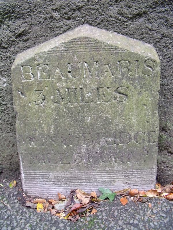
In 1805 Viscount Thomas James Warren Bulkeley (7th Viscount) made a new road through his land to run along the straits and built a sea-wall 5ft(1.5m) high to protect it. It was opened to the public in 1806. In 1828 it became a turnpike road and the approaches to both Menai Bridge and Beaumaris were improved. The milestone dates from the establishment of the turnpike in 1828, and is one of four originally placed along its route, all of which survive.

Exterior

Dressed granite slab, with shaped (pointed) top, cut with lettering reading: BEAUMARIS / 3 MILES / MENAI BRIDGE / 1 MILE 3 FURLS.

Reasons for Listing

Listed as a fine example of a milestone with considerable local historical significance.

External Links

External links are from the relevant listing authority and, where applicable, Wikidata. Wikidata IDs may be related buildings as well as this specific building. If you want to add or update a link, you will need to do so by editing the Wikidata entry.

Recommended Books

Other nearby listed buildings

  • II Craig-y-Don
    Situated in its own grounds sloping down towards the Menai Straits; set back from the SE side of the A545 Beaumaris Road, along which run the boundary walls. Prominent entry beside lodge, tree-lined
  • II Garden house at Min y Twr
    Within the private grounds of Min y Twr, in an elevated location above the NW side of the A545 Beaumaris Road out of Menai Bridge.
  • II Coachhouse at Craig-y-Don
    Set back from the SE side of the A545 Beaumaris Road, the coachhouse is located to SW of the house and close to the water’s edge; reached by the same drive.
  • II Boat-house at Craig-y-Don
    Set back from the SE side of the A545 Beaumaris Road. The boat-house is located at the foreshore of the Menai Straits to SW of the coach-house and stables.
  • II Tower and walls at Min y Twr
    Within the private grounds of Min y Twr, in an elevated location above the NW side of the A545 Beaumaris Road out of Menai Bridge.
  • II Lodge at Craig-y-Don
    Set at the SE side of the A545 Beaumaris Road at the entry to the drive to Craig y Don above and to the NE of the house.
  • II* Plas Rhianfa
    Set back from the SE side of the A545 Beaumaris Road out of Menai Bridge towards Beaumaris.
  • II Gate-house, with gate-piers and retaining wall to courtyard, Plas Rhianfa
    Set back from the SE side of the A545 Beaumaris Road out of Menai Bridge towards Beaumaris.

BritishListedBuildings.co.uk is an independent online resource and is not associated with any government department. All government data published here is used under licence. Please do not contact BritishListedBuildings.co.uk for any queries related to any individual listed building, planning permission related to listed buildings or the listing process itself.

British Listed Buildings is a Good Stuff website.