Approximate Location Map
Large Map »
Latitude: 51.8126 / 51°48'45"N
Longitude: -2.7135 / 2°42'48"W
OS Eastings: 350906
OS Northings: 212900
OS Grid: SO509129
Mapcode National: GBR FL.WTTS
Mapcode Global: VH86T.XPBV
Plus Code: 9C3VR77P+2H
Entry Name: The Malt House Coffee Shop
Listing Date: 3 September 2003
Last Amended: 10 August 2005
Grade: II
Source: Cadw
Source ID: 81298
Building Class: Industrial
ID on this website: 300081298
Location: About 50m from junction with Whitecross Street. Part of a group in the important residential street leading south-east from the parish church.
County: Monmouthshire
Town: Monmouth
Community: Monmouth (Trefynwy)
Community: Monmouth
Built-Up Area: Monmouth
Traditional County: Monmouthshire
Tagged with: Architectural structure
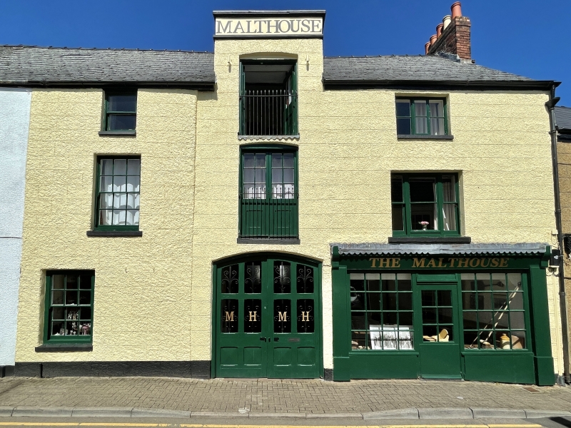
Multi-period building with complex history. There is said to be archaeological evidence of occupation of the site well before the present buildings. Formerly a maltings, and then a garage. The large former maltings block was built after John Wood's map of 1835, but the block on the street line is probably an adaptation of already existing buildings. One of the roof trusses in the front block has notched lapped and pegged joints possibly indicating C18 origins. The overall character of the rear block appears to be mid C19, but the different patterns of roof trusses in the rear block (some evidence also of fire?) also suggest a multi-period building, as do the differing patterns of iron columns in this block. The present vehicle entrance doors are said to be copies of the originals; if this is so, then a remodelling in the later C19 is likely. Not all this evidence was seen at resurvey and details have been taken from the previous list description.
The section to the left of the front block was until recently a separate unit.
Recent restoration re-opened vehicle doorway to former size, fitting new doors and replacing unsympathetic doors and windows, as well as adding a new C19 style shopfront.
Heavily rough-cast render, scribed to imitate stonework, Welsh slate roofs. Front block screens small courtyard with flanking rooms; large maltings block to rear is much broader. Front block of three windows, three storeys. On the left on the top floor a small sash window with 1 over 1 panes, on first floor a 6 over 6 pane sash window, on the ground floor a 6 over 6 pane window, formerly a door. To centre wall runs up to accommodate camber-headed loading door on top floor with individual raised parapet above; similar doorway to first floor; broad vehicle doorway below. To right, 3-light casement window on top floor, tripartite sash on first floor; reproduction C19 style multi-pane shopfront below.
The rear elevation of the maltings block shows coursed red sandstone rubble walling with brick framed openings and a Welsh slate roof.
Interior not seen at resurvey. List description reports a small courtyard with visible walling in brick flanked by ranges which are currently tearooms. Bay over entrance has C19 hoist and trapdoors. The large rear block is on three storeys. Lowest level has heavy beams and closely spaced joists; long central beam supported on iron columns (some from Bright Foundry, Carmarthen). Similar construction to middle floor. The top floor has low-set king-post roof trusses of differing patterns; at south-east end possible evidence of fire damage. The ground floor is said to retain a malting kiln with a rare brick vault and evidence of a perforated drying floor.
Included for its special interest as a multi-period industrial building of definite character.
External links are from the relevant listing authority and, where applicable, Wikidata. Wikidata IDs may be related buildings as well as this specific building. If you want to add or update a link, you will need to do so by editing the Wikidata entry.


Other nearby listed buildings
