Approximate Location Map
Large Map »
Latitude: 52.9095 / 52°54'34"N
Longitude: -4.0027 / 4°0'9"W
OS Eastings: 265420
OS Northings: 336556
OS Grid: SH654365
Mapcode National: GBR 5W.NL6D
Mapcode Global: WH55V.H469
Plus Code: 9C4QWX5W+RW
Entry Name: Nant Pasgan-mawr
Listing Date: 20 October 2008
Last Amended: 20 October 2008
Grade: II*
Source: Cadw
Source ID: 87558
Building Class: Domestic
ID on this website: 300087558
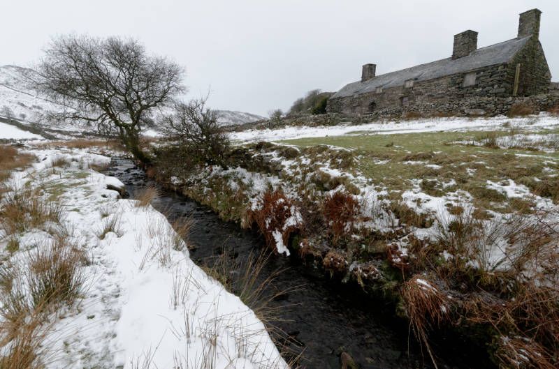
Location: In an isolated upland location on the NW side of the little valley of the Nant Ddu, beyond the road-head of a lane which trends ESE from Llyn Tecwyn Isa, and follows the valley beyond Caerwych. The pr
County: Gwynedd
Community: Talsarnau
Community: Talsarnau
Locality: Llandecwyn
Traditional County: Merionethshire
Tagged with: Building
The core of the house comprises a cruck and stone-built storeyed house of 3 bays. By analogy with other houses of similar form in the region, it is probably mid C16. Structurally, it combined crucks with stone walls from the outset, and was probably storeyed from the beginning, though it has been suggested (by Richard Suggett) that the hall bay may once have been open, and the hall fireplace with its stair a reconstruction. In its present form, it represents a typical sub-medieval Snowdonia house, storeyed, with end chimneys and 2-unit plan. It has a principal fireplace serving the hall (with a staircase alongside the stack), and a second chimney at the service end, possibly with a small ground floor fireplace (now blocked), and a more substantial fireplace serving a principal chamber at first floor level. The ceiling comprises substantial stop-chamfered cross-beams, and heavy joists, which are chamfered in the 2 hall-bays, and plainer in the service end bay. The beam between this bay and the former cross passage retains the mortices of a partition, with evidence for three doorways into the service end. The house was extended at each gable end: beyond the hall chimney, the storeyed extension comprised a heated chamber at first floor, and a ground-floor room without direct access from the house - probably a byre or stable. It may have been added not longer after the house was built. At the lower end gable, the extension is clearly ancillary to the house and may be considerably later.
A long and low building, retaining hall-house proportions, with in-line extensions to each gable end. Roughly coursed rubble stone walls on projecting boulder footings, with slate roof. Fine chimneys mark the original gable ends, with a further very similar stack on the NE gable end: all three have drip-stones and traces of over-sailing caps. Doorway off-set to left of centre, with fine voussoir-headed archway. Windows to either side (2-pane sashes in earlier openings); 3 catslide dormers(reconstructed in the later C20) not quite aligned above. 3 small windows to rear, that to centre aligned with entrance, and probably replacing an earlier cross-passage doorway. Extension against NE gable has single dormer window, and doorway in gable end. Loft doorway at rear, accessed by rebuilt external staircase. SW extension has doorway in front elevation, and wide pitching door to upper rear. Lean-to against rear is also a later addition, and probably served as a cattle shelter.
The house retains its context amongst small fields with the remains of several field cow-houses.
The house is structurally articulated by the two pairs of collared cruck trusses which are embedded in the stone walls and carried on slightly projecting pad-stones. The trusses have pronounced elbows, and that over the hall is seated higher in the wall than the truss between hall and service end. Cross-beams supporting the ceiling lie alongside the trusses but are not jointed into them. The roof has two tiers of purlins, the upper of which lie directly on the cruck-blades, but the lower purlins are supported on short spurs above the blades. The house retains significant elements of its early arrangement, notwithstanding loss of partition between hall and service end. The arrangement of mortices in the beam between service end and hall passage indicates that the service end was once divided into three small units. These may have been parlour, buttery and stair - a trimmer beam for a staircase survives; there is also evidence of a small fireplace, suggesting that one of these rooms was a small parlour. Hall and service end are differentiated by the level of detail in the ceiling: hall (including passage bay) has chamfered joists, whilst there are plain joists to service end. Fireplace bay of hall now lacks ceiling, but slots for joists clearly visible in central cross-beam, and on both sides of a further beam set just forward of the chimney (giving weight to the suggestion that in its present form the fireplace is not primary). Staircase alongside hall stack; the hall fireplace has chamfered timber bressumer; inset within it is a bread oven and grate, which has round-headed archway through smoke-screen wall, crane, and ash-pit. Substantial fireplace with similar bressumer to first floor chamber over service end. Slots in the collar of the truss at this end indicate the position of a partition delineating a first floor chamber.
Addition against SW gable has flue in rear corner - perhaps once serving a wash-boiler or drying kiln.
Listed at grade II* as an important survival of an early Merioneth farmhouse, a rare example of the use of crucks combined with stone construction - important evidence for the transition from timber to stone building traditions in this region. In plan and layout as well as construction, the house appears to mark the transition from a medieval open hall tradition to that of the storeyed house, and represents an early stage in the emergence of a strongly regional post-medieval building tradition (the Snowdonia house).
External links are from the relevant listing authority and, where applicable, Wikidata. Wikidata IDs may be related buildings as well as this specific building. If you want to add or update a link, you will need to do so by editing the Wikidata entry.


Other nearby listed buildings
