Approximate Location Map
Large Map »
Latitude: 53.1384 / 53°8'18"N
Longitude: -3.6806 / 3°40'50"W
OS Eastings: 287672
OS Northings: 361463
OS Grid: SH876614
Mapcode National: GBR 69.66DM
Mapcode Global: WH65Z.FCKV
Plus Code: 9C5R48Q9+9Q
Entry Name: Church of St Winifred
Listing Date: 23 June 1967
Last Amended: 17 March 1999
Grade: II
Source: Cadw
Source ID: 89
Building Class: Religious, Ritual and Funerary
ID on this website: 300000089
Location: The parish church stands in a rectilinear churchyard on an elevated site to the SE of the village centre.
County: Conwy
Town: Abergele
Community: Llangernyw
Community: Llangernyw
Locality: Gwytherin
Traditional County: Denbighshire
Tagged with: Church building
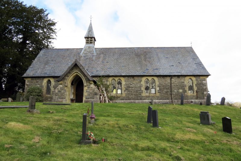
According to tradition a church was established at Gwytherin in the early medieval period and legend has it that Saint Winefrede became abbess of a convent here. Documentary references to 'Ecclesia de Gwytherin...' date from 1254. The church had become very delapidated by the 1860s and was entirely rebuilt in 1867 - 69 by Lloyd Williams and Underwood at a cost of £750, as a single cell like its predecessors. The foundations of the earlier church were incorporated on the N side and some earlier material may also have been used to complete the E gable. The church was rededicated in 1990 after redundancy in 1982 and eight years of disuse.
Simple Victorian Gothic single-cell church with S gabled porch, N lean-to vestry and a small louvred bellcote with slated spirelet set above the roof ridge in line with the porch. Built of random grey shale rubble with sandstone dressings; slate roofs with plain clayware ridge. Single course chamfered sandstone ashlar plinth at base of walls with rubble foundation offset beneath plinth on N side. Rock faced quoins with draughted arrises surmounted by corbels supporting roof verges. Single and double cusped lancet windows in N and S walls. Two-centred E window has 3 cusped lights with a trefoil, subsidiary lights and stepped hood mould under a rubble relieving arch; W window has 3 cusped stepped lights. Cusped lancet windows in vestry. All windows have leaded lights with plain and tinted glass quarries. S wall of porch flanked by buttresses with sandstone kneelers has two-centred doorway, with chamfered surrounds and hoodmould with cube stops.
The church is sited on an elevated spur of ground, the highest point in the enclosure, which falls steeply on the N and E sides. The churchyard is bounded by a stream to the N, a stone wall on the NW and E sides and modern fences to the S and SW. In front of the wall to the NW there is a trace of a relict bank. Monuments in the churchyard are regularly laid out and include ledger stones dating from the late C17 and early C18 and a number of C18 table tombs. To the N of the church there is a row of four standing stones dated to C5-6 one of which bears an incised inscription in Latin.
Open rafter roof in five bays supported on arch-braced trusses with raking struts. Walls with splayed window embrasures are plastered and limewashed. The nave floor is boarded beneath the pews and the aisle is paved with plain clay tiles. Two steps up to the tiled sanctuary floor. The porch has a simple open rafter roof, plastered wall and plain clay tile floor. The S door of the church has a high two- centred arch with chamfered dressings with broach stops. The font has a medieval octagonal bowl which diminishes downwards in a convex profile which rests on a C19 stem. Monuments include a marble mural tablet in N wall of 1848/61, an Incorporated Church Building Society panel dated 1910 in S wall and an undated painted and signwritten wooden benefaction board. A sepulchral slab set in the N wall above the sanctuary steps bears an inscribed C14 expanded arm cross. A second slab of similar date is set in the lower sanctuary step has an incised floreated cross, a representation of a chalice and missal and an inscription commemorating Llaywarch Cappellanus - ie chaplain. Small mediaeval dug-out wooden chest with original lock plate in sanctuary.
Included as a Victorian Gothic rural church with medieval origins.
External links are from the relevant listing authority and, where applicable, Wikidata. Wikidata IDs may be related buildings as well as this specific building. If you want to add or update a link, you will need to do so by editing the Wikidata entry.


Other nearby listed buildings
