Approximate Location Map
Large Map »
Latitude: 51.3202 / 51°19'12"N
Longitude: -2.203 / 2°12'10"W
OS Eastings: 385951
OS Northings: 157920
OS Grid: ST859579
Mapcode National: GBR 1ST.1W8
Mapcode Global: VH972.R2RR
Plus Code: 9C3V8QCW+3R
Entry Name: Lady Brown's Cottages
Listing Date: 26 November 1976
Grade: II
Source: Historic England
Source ID: 1021634
English Heritage Legacy ID: 314105
ID on this website: 101021634
Location: Trowbridge, Wiltshire, BA14
County: Wiltshire
Civil Parish: Trowbridge
Built-Up Area: Trowbridge
Traditional County: Wiltshire
Lieutenancy Area (Ceremonial County): Wiltshire
Church of England Parish: Trowbridge St James
Church of England Diocese: Salisbury
Tagged with: Cottage
POLEBARN ROAD
1.
5411
(South West Side)
Nos 1 to 5 (consec)
(Lady Brown's Cottages)
ST 8557 7/336
II GV
2.
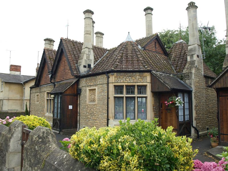
1899 by A. S. Goodridge of Bath. A pair of single storey Tudor style picturesque
almshouses, originally 3 per block. Snecked rubble with timber and brick infil
to gables of Nos 1 and 2 and tile hung gables to Nos 3, 4 and 5. 2 gables to each
front. 7 tall chimneys per cottage block, paired octagonal shafts with coed capping
and stepped bases, square pantile roofs with crested ridges. The plan and elevations
are symmetrical. The main ridge has a pair of cross ridges to centre and 2 lower
hipped gables to angled corners; the roof returned across main gables and form
turret at rear of each block. Porches centre and at sides. Corners angled with
3 light mullion and transom windows having decorative leadwork in upper lights.
A pair of similar windows to centre. 4 tablets in walls - 2 with religious sentiments,
1 with coat of arms and 1 with memorial tablet. The doors retain the original
painted house-names: Oleander Cottage, Hyathinthe Cottage, Jasmine Cottage and
Cedar Cottage, Cypress Cottage, Olive Cottage.
Rosefield Cottage and wall, Rosefield and Homefield with gatepiers and gates, wall
between Rosefield and Police Station form a group with Nos 1 to 15 (consec)
Listing NGR: ST8595157920
External links are from the relevant listing authority and, where applicable, Wikidata. Wikidata IDs may be related buildings as well as this specific building. If you want to add or update a link, you will need to do so by editing the Wikidata entry.


Other nearby listed buildings
