Approximate Location Map
Large Map »
Latitude: 52.2436 / 52°14'36"N
Longitude: 0.7141 / 0°42'50"E
OS Eastings: 585399
OS Northings: 264067
OS Grid: TL853640
Mapcode National: GBR QF0.7CN
Mapcode Global: VHKD4.BVDZ
Plus Code: 9F426PV7+CM
Entry Name: 15, Hatter Street
Listing Date: 12 July 1972
Grade: II
Source: Historic England
Source ID: 1022529
English Heritage Legacy ID: 466899
ID on this website: 101022529
Location: Bury St Edmunds, West Suffolk, IP33
County: Suffolk
District: West Suffolk
Civil Parish: Bury St Edmunds
Built-Up Area: Bury St Edmunds
Traditional County: Suffolk
Lieutenancy Area (Ceremonial County): Suffolk
Church of England Parish: Bury St Edmunds St Mary
Church of England Diocese: St.Edmundsbury and Ipswich
Tagged with: Building
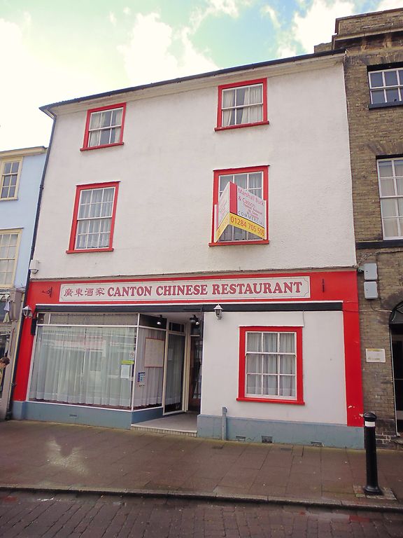
BURY ST EDMUNDS
TL8564SW HATTER STREET
639-1/14/424 (West side)
12/07/72 No.15
GV II
House; now a restaurant with living accommodation above. Early
C19 front; early C16 core. Timber-framed and roughcast with a
shallow pitched roof of C20 Roman tiles.
EXTERIOR: 3 storeys and cellar. 2 windows to each storey:
12-pane sashes to the 1st storey, 6-pane to the top storey;
one shop window with plate glass and one 12-pane sash to the
ground storey with a C20 recessed entry between them.
INTERIOR: cellar walls partly of flint with large blocks of
stone. Fragmentary remains of timber-framing on the ground
storey, in 2 bays; probably originally jettied along the
front. The main post of the rear wall is now free-standing on
a small section of original sill-beam: the post is moulded
down its sides and a long shaft has been hacked off the front
below the remains of a decorated capital with a long empty
mortice for a brace above it.
On the 1st storey 2 rooms have been made into one with
boxed-in beams. The top storey is an early C19 addition.
Extensions at the rear of the same date, and a stair with
stick balusters, curved and wreathed handrail and bracketed
treads.
Listing NGR: TL8539964067
External links are from the relevant listing authority and, where applicable, Wikidata. Wikidata IDs may be related buildings as well as this specific building. If you want to add or update a link, you will need to do so by editing the Wikidata entry.


Other nearby listed buildings
