Approximate Location Map
Large Map »
Latitude: 52.2422 / 52°14'31"N
Longitude: 0.7178 / 0°43'4"E
OS Eastings: 585653
OS Northings: 263922
OS Grid: TL856639
Mapcode National: GBR QF0.G8V
Mapcode Global: VHKD4.DXB1
Plus Code: 9F426PR9+V4
Entry Name: Number 10 and Attached Outbuilding
Listing Date: 2 September 1985
Grade: II
Source: Historic England
Source ID: 1022550
English Heritage Legacy ID: 466920
ID on this website: 101022550
Location: Bury St Edmunds, West Suffolk, IP33
County: Suffolk
District: West Suffolk
Civil Parish: Bury St Edmunds
Built-Up Area: Bury St Edmunds
Traditional County: Suffolk
Lieutenancy Area (Ceremonial County): Suffolk
Church of England Parish: Bury St Edmunds St Mary
Church of England Diocese: St.Edmundsbury and Ipswich
Tagged with: Building
BURY ST EDMUNDS
TL8563NE HONEY HILL
639-1/11/446 (South side)
02/09/85 No.10
and attached outbuildings
GV II
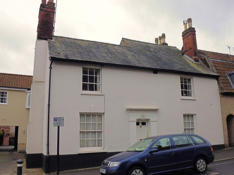
House. Early C18, with early C19 front. Brick front, stucco
rendered and lined, with slate roof. The western half of the
house, originally a long range set gable-on to the street,
with a brick-vaulted cellar below, has been re-roofed in line
with the rest of the front, though with a higher ridge. The
east gable of the re-roofed section, in a mixture of flint,
brick and stone, is dated 1806. 2 end chimney-stacks that on
the east set externally, both with plain red brick shafts.
Bracketed eaves cornice.
EXTERIOR: 2 storeys; part attic; cellar. 2 windows to each
storey: small-paned sashes in deep reveals, longer on the
ground floor than those above; on the left wider also.
Segmental keystones. Slightly recessed 6-panelled door with
the top 2 panels glazed; solid projecting surround with flat
pilasters, plain frieze and cornice, and a slightly arched
head to opening; a slipped keystone bears the head of a
smiling bearded man.
The rear range is in a mixture of flint and re-used Abbey
stone. Stone arches to 2 rear windows, each with a keystone
bearing a rampant lion holding a garland. The eastern half of
the house is butted up against the older range with a straight
joint in the walling; it blocks one upper window and partly
covers the dated gable.
Adjoining the west end of the house is an outbuilding of the
same height: front of re-used stone and random brick,
colourwashed; rebuilt wall in red brick; gable-end rendered;
clay-pantiled gambrel roof; 2 high double doors.
INTERIOR: a C18 duck's nest grate in one rear upper room; in
the front upper rooms a pair of matching cast-iron grates of
c1830.
Listing NGR: TL8565363922
External links are from the relevant listing authority and, where applicable, Wikidata. Wikidata IDs may be related buildings as well as this specific building. If you want to add or update a link, you will need to do so by editing the Wikidata entry.


Other nearby listed buildings
