Approximate Location Map
Large Map »
Latitude: 50.8364 / 50°50'10"N
Longitude: -0.8208 / 0°49'14"W
OS Eastings: 483129
OS Northings: 104757
OS Grid: SU831047
Mapcode National: GBR DGQ.H99
Mapcode Global: FRA 965W.G1Z
Plus Code: 9C2XR5PH+HM
Entry Name: The Black Boy Inn
Listing Date: 16 January 1980
Grade: II
Source: Historic England
Source ID: 1026455
English Heritage Legacy ID: 300616
ID on this website: 101026455
Location: Fishbourne, Chichester, West Sussex, PO18
County: West Sussex
District: Chichester
Civil Parish: Fishbourne
Built-Up Area: Fishbourne
Traditional County: Sussex
Lieutenancy Area (Ceremonial County): West Sussex
Church of England Parish: Fishbourne St Peter and St Mary
Church of England Diocese: Chichester
Tagged with: Inn
BOSHAM CHICHESTER ROAD (south side)
SU 80 SW FISHBOURNE
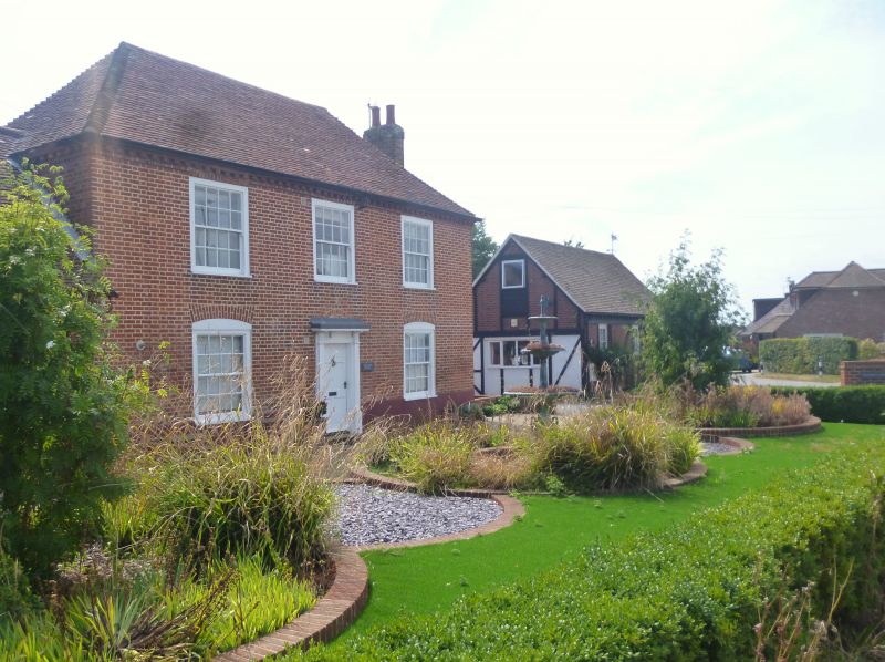
16/613 The Black Boy Inn
16.1.80
- II
C18. Two storeys. Three windows. Red brick. Modillion eaves cornice.
Hipped tiled roof. Doorway with pilasters, projecting cornice and door of six
panels.
Listing NGR: SU8312904757
External links are from the relevant listing authority and, where applicable, Wikidata. Wikidata IDs may be related buildings as well as this specific building. If you want to add or update a link, you will need to do so by editing the Wikidata entry.


Other nearby listed buildings
