Approximate Location Map
Large Map »
Latitude: 51.0601 / 51°3'36"N
Longitude: -0.3309 / 0°19'51"W
OS Eastings: 517064
OS Northings: 130298
OS Grid: TQ170302
Mapcode National: GBR HJN.F4T
Mapcode Global: FRA B669.T2H
Plus Code: 9C3X3M69+2J
Entry Name: 24-26, the Causeway
Listing Date: 20 May 1949
Grade: II
Source: Historic England
Source ID: 1027546
English Heritage Legacy ID: 298128
ID on this website: 101027546
Location: Horsham, West Sussex, RH12
County: West Sussex
District: Horsham
Electoral Ward/Division: Denne
Parish: Non Civil Parish
Built-Up Area: Horsham
Traditional County: Sussex
Lieutenancy Area (Ceremonial County): West Sussex
Church of England Parish: Horsham St Mary the Virgin
Church of England Diocese: Chichester
Tagged with: Building
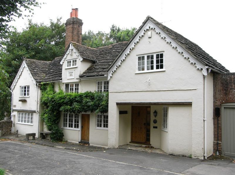
THE CAUSEWAY
1.
1236
(West Side)
Nos 24 to 26 (consec)
TQ 1730 1/13 20.5.49.
II GV
2.
Dated 1615. Originally one house, now 3 cottages. Timber-framed house with plastered
front, the ground floor rebuilt in brick (plastered). The upper floor is partly
tile-hung towards churchyard. The house consisted of a recessed centre and 2 projecting
wings of which the 1st floor overhung on moulded bressumers, but the south wing
has been underbuilt and the north wing altered to make a shed with doors on ground
floor. The wings are gabled with scalloped bargeboards (renewed). In the centre
is a 3rd small gable above a dormer window. Horsham slab roof. 2 storeys and attics
in centre and north gable. 4 windows. All the windows are modern casements, with
the exception of the attic window in the centre gable which is original.
The Manor House, Stables to the south and Nos 24 to 31 (consec) form a group with
Nos 1 to 7 (odd) Blackhorse Way and with all the listed buildings in South Street.
All the listed buildings in The Causeway form a very important group with all the
listed buildings in Market Square and with South Street.
Listing NGR: TQ1705330301
External links are from the relevant listing authority and, where applicable, Wikidata. Wikidata IDs may be related buildings as well as this specific building. If you want to add or update a link, you will need to do so by editing the Wikidata entry.


Other nearby listed buildings
