Approximate Location Map
Large Map »
Latitude: 52.7046 / 52°42'16"N
Longitude: -2.557 / 2°33'25"W
OS Eastings: 362460
OS Northings: 312028
OS Grid: SJ624120
Mapcode National: GBR BS.2P61
Mapcode Global: WH9D1.P8LX
Plus Code: 9C4VPC3V+R5
Entry Name: Churchyard Boundary Wall
Listing Date: 8 April 1983
Grade: II
Source: Historic England
Source ID: 1030940
English Heritage Legacy ID: 362517
ID on this website: 101030940
Location: Wrockwardine, Telford and Wrekin, Shropshire, TF6
County: Telford and Wrekin
Civil Parish: Wrockwardine
Traditional County: Shropshire
Lieutenancy Area (Ceremonial County): Shropshire
Church of England Parish: Wrockwardine St Peter
Church of England Diocese: Lichfield
Tagged with: Building
1.
5362
SJ 6212
3/660
WROCKWARDINE
WROCKWARDINE
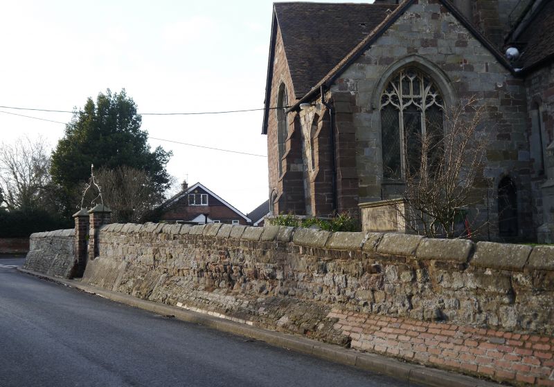
Churchyard boundary wall
II
GV
2.
Circa C18 retaining wall for churchyard which is at higher level than road.
Sandstone with saddleback coping stones. The south-east side is buttressed with
ramped brickwork. Gateways to south-west and south-east sides are late C19 with
wrought iron overthrows.
Listing NGR: SJ6246012028
External links are from the relevant listing authority and, where applicable, Wikidata. Wikidata IDs may be related buildings as well as this specific building. If you want to add or update a link, you will need to do so by editing the Wikidata entry.


Other nearby listed buildings
