Approximate Location Map
Large Map »
Latitude: 51.3805 / 51°22'49"N
Longitude: 0.5223 / 0°31'20"E
OS Eastings: 575623
OS Northings: 167619
OS Grid: TQ756676
Mapcode National: GBR PPW.DVC
Mapcode Global: VHJLV.0KGL
Plus Code: 9F329GJC+5W
Entry Name: 19, Maidstone Road
Listing Date: 27 September 2002
Grade: II
Source: Historic England
Source ID: 1031909
English Heritage Legacy ID: 489802
ID on this website: 101031909
Location: Chatham, Medway, Kent, ME4
County: Medway
Electoral Ward/Division: Chatham Central
Parish: Non Civil Parish
Built-Up Area: Chatham
Traditional County: Kent
Lieutenancy Area (Ceremonial County): Kent
Church of England Parish: Chatham St Mary and St John
Church of England Diocese: Rochester
Tagged with: Building
This list entry was subject to a Minor Amendment on 14/04/2020
762-1/0/10004
CHATHAM
MAIDSTONE ROAD
No 19
27-SEP-02
II
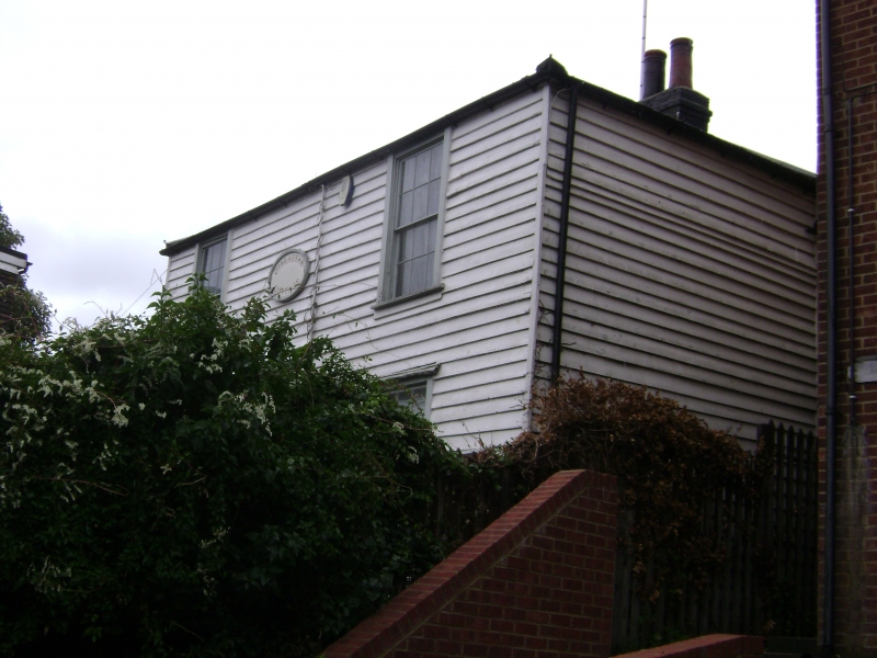
Cottage. Circa 1820 with mid C19 addition to north. Timber framed, clad in weatherboarding with hipped tiled roof and brick chimneystacks. Original part of two storeys two windows with north addition of two storeys one window.
EXTERIOR: front elevation retains original architraves throughout and the ground floor retains original sixteen-pane sashes. First floor sashes have been replaced by C20 casements. To the centre is an original porch with ogee-headed timber roof with acorn finial and latticework panels. Original six-panelled door with door knocker and stone steps. The south side has a single window on the ground floor with original surround but a replacement casement window. The rear or east side has a pair of brick chimneystacks set flush with the wall. The northern stack remains intact with chimneypots but the southern stack has been removed above eaves level. There is a small casement window between the two chimneystacks. To the north is a set back one bay mid C19 extension, also clad in weatherboarding with a hipped slate roof and with one original casement window.
INTERIOR: not inspected.
HISTORY: a structure is shown on this site on the 1843 Tithe Map. 1866 edition of the 25 inch Ordnance Survey map shows both the building and the north extension clearly together with a large carefully laid out garden. At the time the property was known as Gibraltar Cottage. The building is shown surrounded by fields to the south, a chalk pit to the east and a blacksmith's shop to the north. Charles Dickens lived nearby at Ordnance Place between 1817 and 1821, and played in the fields which were later replaced by the railway and station as is mentioned in one of his magazine articles and he may have seen the building before the family moved to London.
External links are from the relevant listing authority and, where applicable, Wikidata. Wikidata IDs may be related buildings as well as this specific building. If you want to add or update a link, you will need to do so by editing the Wikidata entry.


Other nearby listed buildings
