Approximate Location Map
Large Map »
Latitude: 52.3494 / 52°20'57"N
Longitude: -1.5872 / 1°35'13"W
OS Eastings: 428217
OS Northings: 272452
OS Grid: SP282724
Mapcode National: GBR 5LC.MK0
Mapcode Global: VHBX9.F6SS
Plus Code: 9C4W8CX7+Q4
Entry Name: 81-85, High Street
Listing Date: 10 November 1971
Grade: II
Source: Historic England
Source ID: 1035281
English Heritage Legacy ID: 307815
ID on this website: 101035281
Location: Castle Green, Warwick, Warwickshire, CV8
County: Warwickshire
District: Warwick
Civil Parish: Kenilworth
Built-Up Area: Kenilworth
Traditional County: Warwickshire
Lieutenancy Area (Ceremonial County): Warwickshire
Church of England Parish: Kenilworth St Nicholas
Church of England Diocese: Coventry
Tagged with: Building
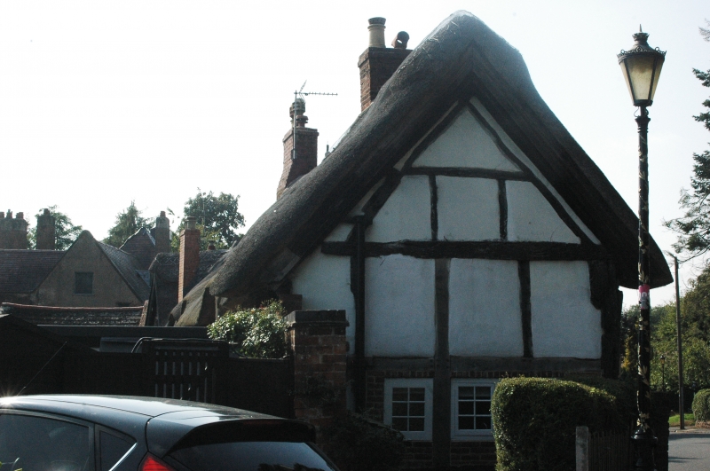
HIGH STREET
1.
1270
(South Side)
Nos 81 to 85 (odd)
SP 2872 SW 5/35
II
2.
Late C16 timber frame and brick with sandstone plinth. Much restored.
Early C19 casements. Modern doorcases. Thatch. No 85 is part of the
same range as Nos 81 and 85 but faced with red brick.
Listing NGR: SP2821772452
External links are from the relevant listing authority and, where applicable, Wikidata. Wikidata IDs may be related buildings as well as this specific building. If you want to add or update a link, you will need to do so by editing the Wikidata entry.


Other nearby listed buildings
