Approximate Location Map
Large Map »
Latitude: 51.3469 / 51°20'48"N
Longitude: -2.251 / 2°15'3"W
OS Eastings: 382613
OS Northings: 160901
OS Grid: ST826609
Mapcode National: GBR 1SC.FQJ
Mapcode Global: VH96V.XDVS
Plus Code: 9C3V8PWX+QH
Entry Name: The Town Bridge
Listing Date: 18 April 1952
Last Amended: 13 March 2017
Grade: I
Source: Historic England
Source ID: 1036011
English Heritage Legacy ID: 312478
Also known as: Bradford-on-Avon Bridge
ID on this website: 101036011
Location: Bradford-on-Avon, Wiltshire, BA15
County: Wiltshire
Civil Parish: Bradford-on-Avon
Built-Up Area: Bradford on Avon
Traditional County: Wiltshire
Lieutenancy Area (Ceremonial County): Wiltshire
Church of England Parish: Bradford-on-Avon Holy Trinity
Church of England Diocese: Salisbury
Tagged with: Road bridge
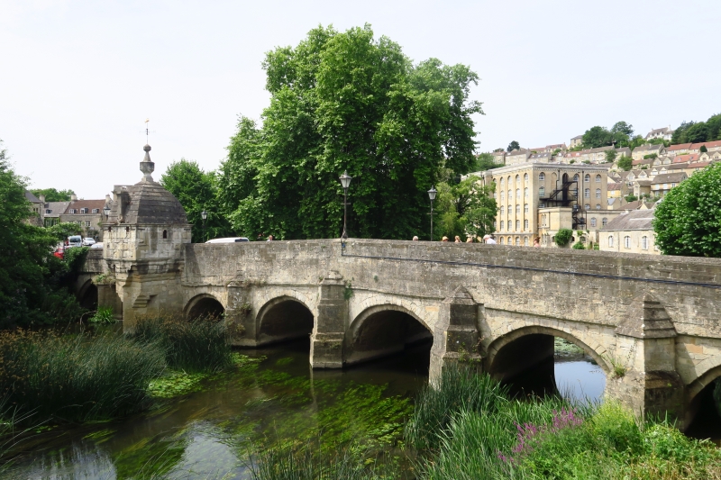
A C13 former packhorse bridge, widened and adapted in the C17 and later, including a former lock-up of probable C17 date and known as the ‘Chapel’.
A C13 packhorse bridge widened in the C17, probably with the addition of the Chapel, and with later alterations.
MATERIALS: ashlar and rubble limestone.
DESCRIPTION: the bridge, over the River Avon, is of nine arches with cutwaters on the upstream (east) side. All arches on the west side are semi-circular and of C17 date. The east side retains two original C13 arches (south end), ribbed and pointed. The remainder are semi-circular and the cutwaters have weather capping. One cutwater towards the south end extends to form a pier and is stepped out in graduated corbelling to support the Chapel. At the south end of the bridge there are steps down to a platform on the west side, the former location of the ford. The low parapet walls adjoining the bridge have some adaptation, including C20 metal railings and bollards. Street lamps, which appear to be mainly of C20 date, are fixed at intervals to the top of both parapet walls along the bridge.
The Chapel is almost square in plan, has four small square window openings with iron bars, two overlooking the river and one on each side. A narrow three-centred arch doorway gives access from bridge. There is a moulded eaves cornice and just below it on the side elevations are two iron tie ends. The domed roof rises (following the square plan of the chapel) in a series of offsets and terminates in a heavy stone finial surmounted by a weather vane. The rotating vane includes a copper-gilt fish, the "Bradford Gudgeon", which may be C16 in date. There is short chimney stack on the river side of roof. The timber plank door has iron fitments and bracing around the door. It opens into a lobby with iron drains at both ends. Beyond the lobby are two cells formed by a stone partition wall. The interior has a stone-vaulted roof in line with the dome. There is ironwork bracing to the walls and around the window openings. Further iron fittings include a bed, a latrine and a further door. Another cell bed appears to be of steel.
The Town Bridge has C13 origins as a packhorse bridge (and an earlier bridge may have stood on the site), and at least two arches of this date survive to the east side. A request for alms for its repair by the Pope is recorded in 1400. A ford (after which the town is named) adjacent on the western side of the bridge was used for larger traffic up until the late-C19, despite the bridge itself having been widened in the C17 to accommodate larger traffic. The round arches on the west side of the bridge date from this period. Many occasions for repair are recorded prior to its widening. The ‘Chapel’ on the south end probably dates from the C17 and was used as a lock-up or ‘blind house’ in the C18. The copper gilt weather vane has a fish emblem and is known as the “Bradford Gudgeon”.
The bridge is shown as Bradford Bridge on the tithe map of 1842. On Ashmead’s 1864 apportionment the building on the bridge is named as the “Blind House”, probably due to its lack of window openings. The Ordnance Survey Map of 1887 shows it as being a ‘Chapel (Magazine)’ and during its history the building may have also served as a toll house for the livestock market. The 1887 map shows breakwaters attached to the west face of the bridge, which are not marked on the revision of 1899 and later mapping, and are no longer extant. Cutwaters on the east face of the bridge are not shown earlier than 1887, but they may be of early-C19 date or earlier. Some adaptation and repair work has taken place to the bridge in the C20 and C21.
The Town Bridge, a C13 former packhorse bridge, widened and with the addition of a lock-up in the C17, is listed at Grade I, for the following principal reasons:
* Historic interest: it is a significant example of a medieval multi-span bridge of which less than 200 examples are now known to survive in England;
* Architectural interest: it is a neatly-made structure with very well constructed arches to the spans and cutwaters, retaining its medieval form and at least two C13 arches;
* Degree of survival: despite later alterations and repairs, it retains a significant proportion of its early fabric and medieval characteristics. Its continued use and adaptation in the C19 is an on-going testament to medieval road building in England.
External links are from the relevant listing authority and, where applicable, Wikidata. Wikidata IDs may be related buildings as well as this specific building. If you want to add or update a link, you will need to do so by editing the Wikidata entry.


Other nearby listed buildings
