Approximate Location Map
Large Map »
Latitude: 51.2047 / 51°12'16"N
Longitude: -2.1904 / 2°11'25"W
OS Eastings: 386791
OS Northings: 145068
OS Grid: ST867450
Mapcode National: GBR 1V5.K03
Mapcode Global: VH97G.ZZCC
Plus Code: 9C3V6R35+VR
Entry Name: Nos 23 and 25 Including Boundary Wall to South of No 25
Listing Date: 31 March 1978
Grade: II
Source: Historic England
Source ID: 1036252
English Heritage Legacy ID: 313019
ID on this website: 101036252
Location: Warminster, Wiltshire, BA12
County: Wiltshire
Civil Parish: Warminster
Built-Up Area: Warminster
Traditional County: Wiltshire
Lieutenancy Area (Ceremonial County): Wiltshire
Church of England Parish: Warminster St Denys
Church of England Diocese: Salisbury
Tagged with: Building
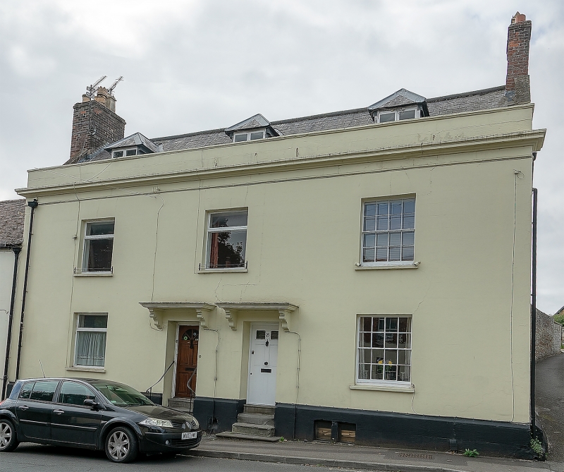
WARMINSTER VICARAGE STREET
1.
5411
(South Side)
Nos 23 and 25 including
boundary wall to south
of No 25
ST 8645 SE 5/292
II
2.
Late C18, altered. 2 storeys and attic with astragal type cornice, rendered
on stout plinth with moulded capping. Slate roof with stone verges and brick
gable end. Chimneys and 3 hipped dormers with 2 light casements. 3 windows
1st floor, 2 on ground floor, right hand range (No 25) retains 4 pane glazing
bar sashes, other windows recently altered by insertion of aluminium casements.
2 separate doors in centre with cut stone brackets to moulded flat hoods,
No 23 has glazed door, No 25 a 6 panel door (upper 2 glazed) and cast iron
knocker. Originally one house, No 25 retains original staircase, mullioned
openings to cellar. No 25 has a 2 storey coursed small rubble extension to
rear with old tile roof and 3 light wooden casements (one per floor) to left.
Garden wall continues from south-west corner, about 100 yds long, also coursed
small rubble, with brick patches. Height varies from about 15 to about 5 ft
from north to south; ramped up to 8 ft over 20 yds. 3 entrances - 2 doors
and a gate.
Listing NGR: ST8679145068
External links are from the relevant listing authority and, where applicable, Wikidata. Wikidata IDs may be related buildings as well as this specific building. If you want to add or update a link, you will need to do so by editing the Wikidata entry.


Other nearby listed buildings
