Approximate Location Map
Large Map »
Latitude: 52.8548 / 52°51'17"N
Longitude: -2.2088 / 2°12'31"W
OS Eastings: 386037
OS Northings: 328604
OS Grid: SJ860286
Mapcode National: GBR 167.0D5
Mapcode Global: WHBDL.1HGT
Plus Code: 9C4VVQ3R+VF
Entry Name: Riverside Farmhouse
Listing Date: 25 April 1980
Grade: II
Source: Historic England
Source ID: 1039085
English Heritage Legacy ID: 272109
ID on this website: 101039085
Location: Chebsey, Stafford, Staffordshire, ST21
County: Staffordshire
District: Stafford
Civil Parish: Chebsey
Traditional County: Staffordshire
Lieutenancy Area (Ceremonial County): Staffordshire
Church of England Parish: Chebsey All Saints
Church of England Diocese: Lichfield
Tagged with: Farmhouse
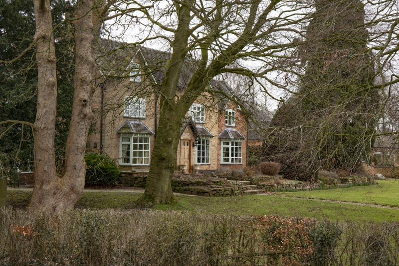
CHEBSEY CHEBSEY
1.
5373
Riverside Farmhouse
SJ 82 NE 14/8
II
2.
Early C19 farmhouse, the core probably C17 with some exposed timber frame at
rear. Buff brick; 2 storeys plus attic. Front, to west, has 2 casement windows
with cambered heads, 2 gabled windows above, 2 canted bay windows and plain
doorway with gabled porch; plain overhanging eaves; tiles.
Listing NGR: SJ8603728604
External links are from the relevant listing authority and, where applicable, Wikidata. Wikidata IDs may be related buildings as well as this specific building. If you want to add or update a link, you will need to do so by editing the Wikidata entry.


Other nearby listed buildings
