Approximate Location Map
Large Map »
Latitude: 55.1272 / 55°7'38"N
Longitude: -1.5117 / 1°30'42"W
OS Eastings: 431234
OS Northings: 581538
OS Grid: NZ312815
Mapcode National: GBR K9W4.JT
Mapcode Global: WHC30.RDB7
Plus Code: 9C7W4FGQ+V8
Entry Name: House 10 Metres North of St Mary's Church
Listing Date: 24 April 1987
Last Amended: 7 April 1988
Grade: II
Source: Historic England
Source ID: 1041347
English Heritage Legacy ID: 236010
ID on this website: 101041347
Location: Blyth, Northumberland, NE24
County: Northumberland
Civil Parish: Blyth
Built-Up Area: Blyth
Traditional County: Northumberland
Lieutenancy Area (Ceremonial County): Northumberland
Church of England Parish: Blyth St Mary
Church of England Diocese: Newcastle
Tagged with: House
In the entry for:-
9/45
BLYTH
WANLEY STREET
(East Side)
House 30 metres
north of
St. Mary's Church
The address shall be
amended to read:-
WANLEY STREET
(East Side)
House 10 metres
north of
St. Mary's Church
------------------------------------
NZ 3181 NW
9/45
24.4.87
BLYTH
WANLEY STREET
(East side)
House 30 metres
north of St.
Mary's Church
GV
II
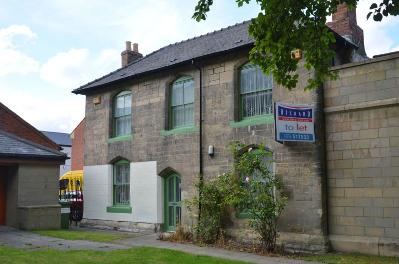
Former headmaster's house for National School. 1858, by A.M. Dunn. Squared
stone with tooled dressings; blue slate roof with cresting of yellow moulded
tiles, upper parts of stacks rebuilt in brick. 2 storeys, 3 bays. Chamfered
plinth. Left-of-centre diagonal-boarded door, and 4-pane sash windows, all in
chamfered surrounds with segmental-pointed heads. Flanking stacks project from
returns. Hipped roof. Rear wing has similar roof and stack.
The National School was built for 250 children; other buildings including
attached block to north-west, have been altered and are not of special interest.
Included for group value with St. Mary's Church (q.v.).
Listing NGR: NZ3123481538
External links are from the relevant listing authority and, where applicable, Wikidata. Wikidata IDs may be related buildings as well as this specific building. If you want to add or update a link, you will need to do so by editing the Wikidata entry.


Other nearby listed buildings
